
Find research datasets worth reusing
Search datasets from major research repositories and use ShareScore to quickly assess how well each record supports discovery, access, and reuse.
3,409
datasets available to search
ShareScore release 0.7.1
Dataset results
3,409 results for “UK”
Data for cyanobacteria, nutrients and color from 588 lakes in Finland Norway Sweden and UK extracted from the WISER database
<p>Data on phosphorus, color, cyanobacteria biovolume, total phytoplankton biovolume and cyanobacteria proportion of the total phytoplankton biovolume used for GAMM</p>
Terrestrial laser scanning data of urban trees in Milton Keynes, UK: individual trees and Treegraph model outputs
<p><strong>TLS_point_clouds:</strong></p> <p>- Data collection: Terrestrial laser scanning data acquired in leaf-off condition in April 2021.</p> <p>- Scanning instrument: We used a RIEGL VZ-400 with a wavelength of 1550 nm, 0.35 mrad beam divergence and 0.04˚ angular resolution.</p> <p>- Locations: The data were collected from three urban sites in Milton Keynes, UK: Avebury Blvd (Ave), Dansteed Way (Dan), and Overgate (Ove).</p> <p>- File information: Each file is an individual tree point cloud in Polygon File Format (.ply), which can be viewed in software such as CloudCompare.</p> <p> </p> <p><strong>Treegraph_outputs:</strong></p> <p>- Description: Model outputs from <em>Treegraph</em> for individual trees.</p> <p>- File naming convention: [TreeID]-[downsample_voxel_length]-[tip_diameter_if_known].*</p> <ul> <li>*.centres.ply: Skeleton nodes of individual trees.</li> <li>*.mesh.ply: Cylinder model of individual trees.</li> <li>*.json: Geometrical and topological attributes at varying scales, from internode and branch to the whole tree.</li> <li>*.txt: Summary of input parameters, logs of intermediate steps, and a statistical overview of whole-tree structural attributes.</li> </ul>
The Risk of Venous Thromboembolism in Systemic Inflammatory Disorders: a United Kingdom (UK) Matched Cohort Study
ClinicalTrials.gov study NCT03835780. IPD Sharing: YES. Countries: 1. Publications: 2.
Data for: Genetic control of grain amino acid composition in a UK soft wheat mapping population
Open the record for dataset details and reuse information.
Appendix II in The Earwig Collection (Dermaptera) of the Manchester Museum, UK, with a complete type catalogue
Appendix II, continued
Appendix II in The Earwig Collection (Dermaptera) of the Manchester Museum, UK, with a complete type catalogue
Appendix II: Correspondence in the Brindle Archive relating to Dermaptera, the Manchester Museum
Fig. 2. A in The Earwig Collection (Dermaptera) of the Manchester Museum, UK, with a complete type catalogue
Fig. 2. A graph showing % of World Dermaptera represented at the Manchester Museum, by family.
Appendix I in The Earwig Collection (Dermaptera) of the Manchester Museum, UK, with a complete type catalogue
Appendix I, continued
Fig. 3. A in The Earwig Collection (Dermaptera) of the Manchester Museum, UK, with a complete type catalogue
Fig. 3. A drawer of the British Dermaptera collection, the Manchester Museum.
Appendix I in The Earwig Collection (Dermaptera) of the Manchester Museum, UK, with a complete type catalogue
Appendix I: Correspondence in the Hincks Archive relating to Dermaptera, the Manchester Museum
Journal subscription expenditure in the UK 2010-2019
<p>This dataset contains payments made by UK higher education institutions for access to academic journals from ten publishers from 2010-2019. The data was obtained by sending Freedom of Information (FOI) requests to institutions through the website What Do They Know. The requests, and all original source data, can be found at https://www.whatdotheyknow.com/user/stuart_lawson/requests.</p> <p>The total expenditure with these ten publishers from 2010-2019 was over £982 million. This includes some gaps in the data, so the true figure is almost certainly greater than £1 billion.</p> <p>The data was originally produced in three stages:</p> <p>- Data for 2010-14 was published at https://doi.org/10.6084/m9.figshare.1186832</p> <p>- Data for 2015-16 was published at https://doi.org/10.6084/m9.figshare.4542433</p> <p>- Data for 2017-19 was published at https://doi.org/10.5281/zenodo.3828461</p> <p>These three datasets contain direct links to the original FOI requests. The present dataset is a combination of these three datasets and contains no additional data.</p>
Solar panels and solar farms in the UK - geographic open data (UKPVGeo)
<p>We present the results of a major crowd-sourcing campaign to create open geographic data for over 260,000 solar PV installations across the UK, covering the vast majority of the capacity in the country. We focus in particular on capturing small-scale domestic solar PV, which accounts for a significant fraction of generation but was until now very poorly documented.</p> <p>The data we introduce will enable decarbonisation at national scales, through forecasting and management of generation, and also serves as a training dataset for machine vision detection of new PV.</p> <p>For a complete description please see <a href="https://www.nature.com/articles/s41597-020-00739-0">the research paper describing the dataset</a>. Please cite this paper in any academic use of the data.</p>
Channel cross section and floodplain water level data from the Allanmore Floodplain, River Dee, Scotland, UK (2013-2018).
<p>Filename: 'Cross Section Data.xls': Cross section data from the River Dee (N=5) and adjacent backwater (N=3) from the floodplain reconnection site. Cross sections surveyed with a real-time kinematic global positioning system (Leica Geosystems 1200) on an annual basis between 2013 and 2018 (twice in 2015 before and immediately after restoration work was completed in October 2015). Elevation data are reported in British National Grid (m above Ordnance Survey datum) format. </p> <p>Filenames 'ML1-ML3 Water Levels.xls': Continuous water table and surface water (15 minute interval) data from three contrasting floodplain observation well sites between 2013 and 2018 (ML1: ditch, ML2: floodplain surface and ML3: backwater). Note there are two data gaps for ML3 due to instrument loss (08/10/2015-16/10/2015 and 18/12/2015-21/06/2016). Water levels were measured with a Troll 100 sensor (ML1 and ML2) and a Frog RX logger/Troll 100 sensor (ML3). All data was corrected for atmospheric pressure using continuous data from a barometric sensor at the site (BaroTroll 100). Water level data are referenced to British National Grid datum. </p> <p>For more details on the methods and results please see the associated article published in the journal<em> Science of the Total Environment</em>:</p> <p>Addy, S. and Wilkinson, M.E. (2021) Embankment lowering and natural self-recovery improves river-floodplain hydrogeomorphic connectivity of a gravel bed river. Science of The Total Environment. https://doi.org/10.1016/j.scitotenv.2020.144626</p> <p> </p> <p> </p>
Preston Park Clocktower, Brighton, UK
This is a far from perfect interpretation of a local monument, as I was testing a new workflow, and eventually had to move on to someting else. I was using stencils to try to paint on bump maps, so was working on 4k textures and I haven't optimised anything. Thank goodness for @sketchfab post processing Thus, the textures area bit huge, but it's quite low poly really, so feel free to see if you can finish it off! The geometry is pretty good and the textures can be easily edited. 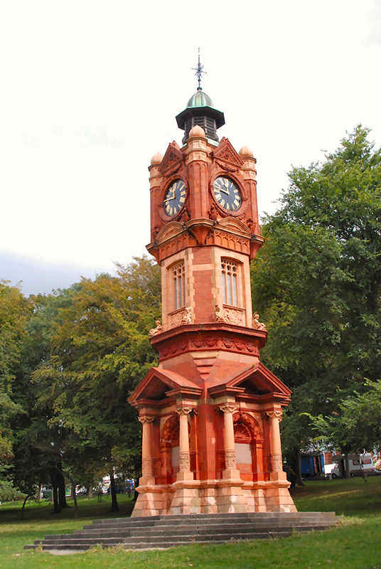 Source: Objaverse 1.0 / Sketchfab
The Font, located at Lichfield Cathedral, UK
The Font, in Lichfield Cathedral, England, made of Caen stone and alabaster, with richly coloured marble pillars, early French Gothic detail, and high relief scenes and figures. This elaborate font with its instructive Bible stories and appealing details was designed by William Slater (1819-1872) and executed by James Forsyth (1827-1910). It dates from about 1862. Model generated from about 100 images taken with an LG G6 smartphone. Source: Objaverse 1.0 / Sketchfab
Ammonite, Science Zone UK
> Ammonoids are a group of extinct marine mollusc animals in the subclass Ammonoidea of the class Cephalopoda. These molluscs, commonly referred to as ammonites, are more closely related to living coleoids (i.e., octopuses, squid and cuttlefish) than they are to shelled nautiloids such as the living Nautilus species.[1] The earliest ammonites appeared during the Devonian, and the last species either vanished in the Cretaceous–Paleogene extinction event, or shortly after during the Danian epoch of the Paleocene. ~ https://en.wikipedia.org/wiki/Ammonoidea - - - 200 images iPhone 13 Pro using the '3x' zoom and square image crop. Purchased from [sciencezone.uk](https://www.sciencezone.uk/) Created in RealityCapture by Capturing Reality from 200 images in 00h:06m:19s. Source: Objaverse 1.0 / Sketchfab
Memorial to Henry Boase, Penzance UK
A memorial to [Henry Boase](https://en.wikipedia.org/wiki/Henry_Boase) Esq in St Mary's churchyard, Penzance UK. Source: Objaverse 1.0 / Sketchfab
Tregiffian burial chamber, Cornwall UK
Tregiffian burial chamber is an early Bronze Age chambered tomb situated in West Penwith, Cornwall. Click the annotations to see the rock art (cup marks) on the monument. These will also provide links to more detailed models of each area. We have also managed to create a [simple 3D surface model of a cup-marked stone from Tregiffian which has been lost](https://sketchfab.com/3d-models/missing-cup-marked-stone-from-tregiffian-111f1b0a46f9404899678f54b6e81e1d) since the 1960s. *The project was funded by a British Academy/Leverhulme small research grant.* Source: Objaverse 1.0 / Sketchfab
Knucklas Castle, Powys, Wales, UK
Knucklas Castle 3D model from a drone flight using Drone Deploy for photogrammetric mapping and processing. Best viewed full screen in HD mode (see icons at bottom of image to switch these on). The stone castle was built by the Mortimers in c. 1220-25 and destroyed by Llewelyn in 1262. It may have been attacked again by Owain Glyndwr in 1402. It is said to have been ruinous and disused by 1403. It is a difficult site to interpret, but appears to have consisted of a stone keep with corner towers. Stone was later robbed from the site for the Knucklas viaduct in the late 19th century, which includes some mock towers in its construction. Source: Objaverse 1.0 / Sketchfab
Chichester, UK
3D model of the historic town of Chichester on the south coast of the UK. The model was generated using Environment Agency airborne LiDAR data, the tree canopy has been hightlighted in green. Source: Objaverse 1.0 / Sketchfab
ScienceDex guides
Understand access before you commit
These curated guides explain access requirements, typical timelines, costs, and reuse considerations for widely used research datasets.
Allen Brain Atlas
Allen Brain Atlas is an Allen Institute collection of brain map atlases, datasets, APIs, and analysis tools covering mouse, human, and non-human primate brain resources.
Annotated Behaviour and Observability Dataset (ABODe)
ABODe is a University of Edinburgh DataShare dataset for behavior classification in group-housed mice using home-cage video, identities, bounding boxes, ground-plate positions, and annotator labels.
DANDI Archive for NWB datasets
DANDI is a BRAIN Initiative archive for publishing and sharing neurophysiology data, including electrophysiology, optophysiology, and behavioral data packaged as NWB and related standards.
International Brain Laboratory public data
The International Brain Laboratory public data releases expose standardized mouse decision-making experiments, including Neuropixels recordings, widefield calcium imaging, behavior, and session metadata accessed through the ONE API.
OpenNeuro
OpenNeuro is a free, open platform for sharing neuroimaging datasets, with public search, dataset pages, and download paths for web, S3, DataLad, and the OpenNeuro CLI.