
Find research datasets worth reusing
Search datasets from major research repositories and use ShareScore to quickly assess how well each record supports discovery, access, and reuse.
320
datasets available to search
ShareScore release 0.9.0
Dataset results
320 results for “CAMP”
Fig. 6. Camp 3 in Additional Amphibians And Reptiles From The Phnom Samkos Wildlife Sanctuary In Northwestern Cardamom Mountains, Cambodia, With Comments On Their Taxonomy And The Discovery Of Three New Species
Fig. 6. Camp 3 in a transitional zone between dry dipterocarp forest and hill evergreen forest at the base of Phnom Samkos, Pursat Province, Cambodia.
Fig. 3 in A New Eocene Rodent from the Lower Arshanto Formation in the Nuhetingboerhe (Camp Margetts) Area, Inner Mongolia
Fig. 3. The dp4 of Archetypomys erlianensis. a, V14622.10, left dp4; b, V14622.11, right dp4; c, V14622.12, right dp4; d, V14622.13, left dp4; e, V14622.14, right dp4; f, V14622.15, right dp4; g, V14622.16, right dp4; h, V14622.17, left dp4; i, V14623.7, left dp4; j, V14623.8, left dp4; k, V14623.9, right dp4; l, left dp4 of Tribosphenomys minutus from the Late Paleocene Subeng locality, Inner Mongolia.
Fig. 2. M2–3 in A New Eocene Rodent from the Lower Arshanto Formation in the Nuhetingboerhe (Camp Margetts) Area, Inner Mongolia
Fig. 2. M2–3 of Archetypomys erlianensis. a, V14622.6, right M2; b, V14622.7, right M2; c, V14622.8, left M2; d, V14623.3, left M2; d1, anterior view of V14623.3; e, V14623.4, left M2; e1, buccal view of V14623.4; f, V14623.5, left M2; f1, posterior view of V14623.5; g, V14622.9, left M2; h, V14623.6, right M3; i, left M2 of Tribosphenomys minutus from the Late Paleocene Subeng locality, Inner Mongolia.
Fig. 6. The m3 in A New Eocene Rodent from the Lower Arshanto Formation in the Nuhetingboerhe (Camp Margetts) Area, Inner Mongolia
Fig. 6. The m3 of Archetypomys erlianensis. a, V14622.29, right m3; b, V14622.30, right m3; c, V14622.31, left m3; d, V14622.32, right m3; e, V14622.33, left m3; f, left m3 of Tribosphenomys minutus from the Late Paleocene Subeng locality, Inner Mongolia.
Fig. 5. The m2 in A New Eocene Rodent from the Lower Arshanto Formation in the Nuhetingboerhe (Camp Margetts) Area, Inner Mongolia
Fig. 5. The m2 of Archetypomys erlianensis. a, V14623.14, right m2; b, V14622.23, right m2; c, V14623.15, left m2; d, V14622.24, left m2; e, V14623.16, left m2; f, V14622.25, left m2; g, V14622.26, left m2; h, V14622.27, left m2; i, V14623.17, left m2; j, V14622.28, right m2; k, left m2 of Tribosphenomys minutus from the Late Paleocene Subeng locality, Inner Mongolia.
Fig. 4. The m1 in A New Eocene Rodent from the Lower Arshanto Formation in the Nuhetingboerhe (Camp Margetts) Area, Inner Mongolia
Fig. 4. The m1 of Archetypomys erlianensis. a, V14623.10, right m1; b, V14622.18, left m1; b1, buccal view of V14622.18; c, V14622.19, right m1; d, V14623.11, right m1; e, V14622.20, left m1; f, V14622.21, right m1; g, V14622.22, right m1; h, V14623.12, left m1; i, V14623.13, right m1; j, left m1 of Tribosphenomys minutus from the Late Paleocene Subeng locality, Inner Mongolia.
Fig. 1. P4 and M1 in A New Eocene Rodent from the Lower Arshanto Formation in the Nuhetingboerhe (Camp Margetts) Area, Inner Mongolia
Fig. 1. P4 and M1 of Archetypomys erlianensis. a, V14623.2, left P4 (or dP4); b, V14622.1, right M1 with metacone broken; c, V14623.1, right M1 (holotype); d, V14622.2, left M1; e, V14622.3, right M1; f, V14622.4, left M1; g, V14622.5, right M1; h, left M1 of Tribosphenomys minutus from the Late Paleocene Subeng locality, Inner Mongolia. All teeth in figures 1–6 are on the same scale.
Nicaragua: Jinotega, Cerro Kilambe: Camp 1, Lat. 13.596944, Long. 85.72528, 23Apr01, col. J. Sunyer (MEL 445877 + 446304/446305, 1 Macho, 2 Hembras). in Cicadidae (Homoptera) de Nicaragua: Catalogo ilustrado, incluyendo especies exóticas del Museo Entomológico de Leon
Nicaragua: Jinotega, Cerro Kilambe: Camp 1, Lat. 13.596944, Long. 85.72528, 23Apr01, col. J. Sunyer (MEL 445877 + 446304/446305, 1 Macho, 2 Hembras).
Nicaragua: Región Autónoma Atlántico Norte: Reserva de Biosfera de BOSAWAS: Cerro Saslaya: Camp 2, alt., 700, m, Lat. 13.733055, Long. 85.01417, 1Apr99, col. J. M. Maes (MEL 445985 y 445987 / 445989, 3 Machos, 1 Hembra). in Cicadidae (Homoptera) de Nicaragua: Catalogo ilustrado, incluyendo especies exóticas del Museo Entomológico de Leon
Nicaragua: Región Autónoma Atlántico Norte: Reserva de Biosfera de BOSAWAS: Cerro Saslaya: Camp 2, alt., 700, m, Lat. 13.733055, Long. 85.01417, 1Apr99, col. J. M. Maes (MEL 445985 y 445987 / 445989, 3 Machos, 1 Hembra).
Rohingya Refugee Camp Fuel Load Dataset (Camp 4Ex, 5, KRC)
<p>A comprehensive survey was conducted on July 2, 2022, to prepare the fuel inventory map featuring dwelling structure, fuel load density, placement of fuel etc. In the 5-day long survey, three camps having contrasting fuel inventory have been examined. They are- Camp 4 Extension (Ex), Camp 5 and Kutupalong Registered Camp (KRC). These camps were selected based on the following features :</p> <ul> <li>Being the youngest of all the camp in Kutupalong, Camp 4 Ex followed a standard design and an average separation distance of 7m.</li> <li>On the other hand, Camp 5 is densely populated, having no visible space between two dwellings. It was one of the largest camps with a population of almost 25 thousand. The Rohingya community there are as equally impoverished as those living in Camp 4 Ext. The shelters of both of these camps are made of cellulose based structure material like wood, bamboo, timber etc., but the dwellings of camp 5 don’t follow any standard design.</li> <li>With a sharp contrast, dwellings in KRC follow a shaded structure consisting of six dwellings under one roof but separated by brick wall or corrugated steel sheet. KRC began informally in 1991, making it the oldest of all camps and its dwellers somewhat self-sufficient. A lot more permanent structure e.g., wooden furnitures, bed, wardrobe, showcase has been found here, increasing its fuel load larger than that of Camp 4 Ex and 5.</li> </ul>
Roman Camps Scotland Dataset
<p>This is an open access dataset containing information about 259 Roman camps in Scotland and has been created for spatial analysis. </p> <p>YOFD = Year of First Discovery</p> <p>MOD = Method of Discovery </p> <p>PUB = First identifiable publication in which camp was mentioned</p> <p> </p>
Renieblas Roman Republican Camps, Spain
The five overlapping and very well preserved Roman camps on the hillside at Atalaya de Renieblas near Soria, Spain are of great importance to the study of the Roman Republican army and its involvement in the conquest of Celtiberian Spain in the 2nd and 1st centuries BC. The camps lie just 8.6km east of the Celtiberian stronghold of Numantia which was finally taken by siege in 133 BC. It is believed that Camp III at Renieblas, and possibly some of the earlier and later camps here, were part of the operations leading up to & after the siege during 154 - 133 BC. Numantia itself is surrounded by a number of siege camps from various campaigns between 195 BC - 72 BC. The final Roman & allied force in 133 BC under Publius Cornelius Scipio Aemilianus is estimated to have been 60,000. 50 cm LiDAR from IGN, Spain visualised in low relief to bring out the detail of the camp defences and internal structures. Source: Objaverse 1.0 / Sketchfab
Camp de Péran, Plédran (22) France
Modélisation du Camp de Péran dans le cadre du projet de thèse de Gérard Matser. Le Camp de Péran est une fortification daté du Xe siècle. Le site est localisé dans la commune de Plédran, à 9 kilomètres au sud-ouest de Saint Brieuc, dans les Côtes-d'Armor. Le site couronne l'extrémité du plateau de l'Urne et surplombe les vallées de l'Urne et du Gouet. The Camp de Péran is a 10th century fortification in the village of Plédran, 9 km south-west of Saint Brieuc. The archaeological site, situated on the Urne plateau, dominates the valley of the Urne and the Gouet. Source: Objaverse 1.0 / Sketchfab
Spanish Civil War Concentration Camp Guard House
Casa de Guarda is a concentration camp located in the north of Guadalajara (Spain). In previous models (https://skfb.ly/outRR) I share some of the barracks were the prisoners lived from 1938 until the end of the war, April 1939 and after. In this case, I brought you something completely different, a guard house. Its configuration is the opposite to the long dug out barraks of the republican prisoners. These are little rectangular houses with stone walls, for a little garrison. They are located at the entrance and key points of the camp and the material culture variates from the one found in the barracks, ammunition as well as alcoholic drinks (it is a cold region) and medecines were found all around the house, which means more availability of things in comparation with the barracks. An identificatory plate was found nearby. This project was carried out by the Incipit, directed by Alfredo González-Ruibal and Luis A. Casero and financed by the Secretariat of Democratic Memory. The 4 models in the description. Source: Objaverse 1.0 / Sketchfab
British-camp-hillfort-dji-inspire-jaymie-james
had a bit of a tricky flight to get this one, the cross winds were pushing the drone to a 45 degree angles,very gusty day so touch and go getting it. the British Camp is a very large hillfort in the Malvern hills near Hereford ,England. has a car park(paid) and plenty of common land if you're too tight to pay.but well worth a visit. https://en.wikipedia.org/wiki/British_Camp. if you want to see any of the other hillforts we've filmed or mapped check them out here https://www.facebook.com/groups/1419169481438389/ Source: Objaverse 1.0 / Sketchfab
Chantier 501, camp 93, bâtiment d'exploitation
Vestiges du bâtiment d'exploitation du camp de Chtchoutchi, sur la ligne 501 Tchoum-Igarka, dans le Yamal (russie). La construction de cette ligne, jamais achevée, dans le grand nord a été ordonnée par Staline en 1947. La construction a employés plusieurs dizaines de milliers de détenus du Goulag, jusqu'en 1953. Plus découvrir plus d'informations sur le bâtiment, sa localisation sur une carte interactive et suivre l'expédition menée pour le documenter, rendez-vous sur [yamal.ch ](https://yamal.ch) 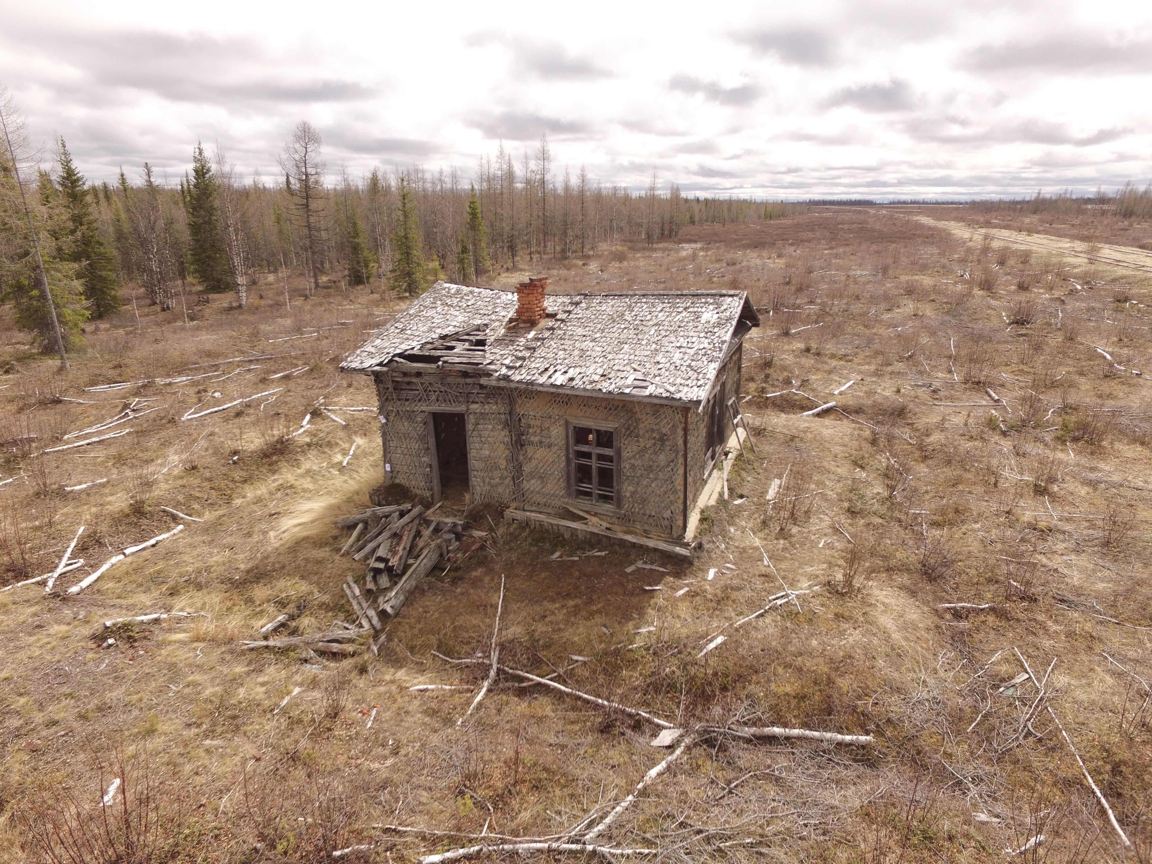 J. André pour Changing Arctic, 2020 Source: Objaverse 1.0 / Sketchfab
Building at Camp George West: test
Again another scan from Camp George West in Golden Colorado. This time of a small building. No editing in any external 3D program. For this I was testing Reality Captures point cloud optimization. Went from over 1.1M faces to 100k faces. There is some noticeable loss of resolution at 100k if you zoom in close enough but other than that not too bad. It would be a nice if you could highlight the areas that you would like more detail in Reality Capture. Here are some other scans from Camp George West. [Cannon at Camp George West v1 test](https://skfb.ly/68trH) [The Other Cannon at Camp George West](https://skfb.ly/6snnE) Created in RealityCapture by Capturing Reality from 143 images in 00h:19m:02s. Source: Objaverse 1.0 / Sketchfab
Kalvika POW camp: Iron stew pot "in situ"
Large iron stew pot left after the Kalvika camp was abandoned. The object measures 1,18 x 1,18 meters. Source: Objaverse 1.0 / Sketchfab
Cawthorn Roman forts and camp near Pickering
The monument includes the remains of two Roman forts, one of which has an attached annexe, a Roman camp and a section of medieval trackway. It is situated on the crest of a gentle south-facing slope at the northern rim of the Vale of Pickering and immediately south of a steep slope known as Cawthorn Banks. Full extensive text at: https://historicengland.org.uk/listing/the-list/list-entry/1007988 Source: Objaverse 1.0 / Sketchfab
Malham Roman Camp
Malham Roman Camp, to the northeast of Malham village (and the Cove). It's visible in the Environment Agency LiDAR but not exactly prominent. The banks and ditches are visible on the ground, but you'll have to use your imagination when filling in the former camp! Elsewhere in the scene are a couple of round cairns (e.g. [Seaty Hill](https://historicengland.org.uk/listing/the-list/list-entry/1010444), the Roman road, and other interesting anthropogenic structures, within a rugged geological landscape of exposed limestone bedrock, river gorges, hummocks, sinkholes, disappearing watercourses, and some great cave systems. [Sentinel-2 timelapse](https://drive.google.com/file/d/1gRJ-08FRgWuZN_pE7LkS8sBZDlt6_6gE/view?usp=sharing) It's an [Historic England Scheduled Monument](https://historicengland.org.uk/listing/the-list/list-entry/1008777) and managed by the [National Trust](https://www.nationaltrust.org.uk/malham-tarn-estate/trails/malham-tarn-archaeology-walk). Credits: [EA LiDAR], QGIS, QGIS2threeJS, RVT Source: Objaverse 1.0 / Sketchfab
ScienceDex guides
Understand access before you commit
These curated guides explain access requirements, typical timelines, costs, and reuse considerations for widely used research datasets.
Allen Brain Atlas
Allen Brain Atlas is an Allen Institute collection of brain map atlases, datasets, APIs, and analysis tools covering mouse, human, and non-human primate brain resources.
Annotated Behaviour and Observability Dataset (ABODe)
ABODe is a University of Edinburgh DataShare dataset for behavior classification in group-housed mice using home-cage video, identities, bounding boxes, ground-plate positions, and annotator labels.
DANDI Archive for NWB datasets
DANDI is a BRAIN Initiative archive for publishing and sharing neurophysiology data, including electrophysiology, optophysiology, and behavioral data packaged as NWB and related standards.
International Brain Laboratory public data
The International Brain Laboratory public data releases expose standardized mouse decision-making experiments, including Neuropixels recordings, widefield calcium imaging, behavior, and session metadata accessed through the ONE API.
OpenNeuro
OpenNeuro is a free, open platform for sharing neuroimaging datasets, with public search, dataset pages, and download paths for web, S3, DataLad, and the OpenNeuro CLI.