
Find research datasets worth reusing
Search datasets from major research repositories and use ShareScore to quickly assess how well each record supports discovery, access, and reuse.
138
datasets available to search
ShareScore release 0.9.0
Dataset results
138 results for “cliffs”
Knockadoon Cliff-Edge Enclosure LI032-022007-
On cliff-edge pasture, on west-facing slope of terrace, above low rock cliff-face on Knockadoon Peninsula, 100m east of the current shoreline of Lough Gur and Garret Island. Cliff-edge enclosure (Site 12) lies within a complex Neolithic and Bronze Age settlement that was discovered during a campaign of archaeological excavation over 18 seasons led by Professor Seán P. Ó Ríordáin at Lough Gur, Co. Limerick. Monument consists of an oval-shaped cliff-edge enclosure measuring 26.5m N-S by 24m E-W enclosed by a stone and earthen bank. Excavated in 1954, Site 12 was never written up by Ó Ríordáin because of his untimely death. The pottery recovered from the excavation was largely 'Western Neolithic (Class I)' . On that basis a Neolithic date (c. 3000 BC) was proposed for the enclosure. The monument is on private land and there is no access to the monument without the landowner's permission. For more detailed description of the monument, visit: https://maps.archaeology.ie/HistoricEnvironment/?SMRS=LI032-022007- Source: Objaverse 1.0 / Sketchfab
Lonely Chapel on the cliff
This is the chapel of "Йоан Летни" (pronounced: Joan Lehtneeh) by the Pchelina dam. It was built in the year of 1350 for the people of the Pchelina Village. Now the only building of once a village as the administration decided to turn it into waterbody for economic and political purposes. Forced to leave, people were offered lands nearby. Source: Objaverse 1.0 / Sketchfab
Detailed data sets of MMP-cliffs, SAR transfer series, RECAP-MMPs and compound activities
<p>An up-to-date version of three MMP-based data sets derived from compounds included in the latest release of ChEMBL is presented. These data sets include activity cliffs, structure-activity relationship (SAR) transfer series, and second generation MMPs based upon retrosynthetic rules. The structural data and information are provided in eight different files comprising the data sets of MMP-cliffs, SAR transfer series, and RECAP-MMPs. Compound activities are incorporated in files of RECAP-MMPs. For transfer series, substituted fragments are also provided. All MMP-cliffs, SAR transfer series with approximate or regular potency progression, and RECAP-MMPs are provided in canonical SMILES representation on a per-target basis separately for the Ki and IC50 subsets. The corresponding files are clearly designated.</p>
Currently available 3D activity cliffs and 2D-analogs of 3D-cliff compounds
<p>Three dimensional activity cliffs (3D-cliffs) were systematically determined based on currently available X-ray structures in PDB. The list of all 236, 292, 595 3D-cliffs that were identified from the K<sub>i</sub>, IC<sub>50</sub>, and K<sub>i</sub>/IC<sub>50</sub> sets, respectively, is provided. In addition, on the basis of matched molecular pairs, the 2D structural analogs of 3D-cliff compounds identified from ChEMBL database (release 19) are given.</p>
Compounds with multi-target activities forming target cliffs and selectivity cliffs
<p>On the basis of high-confidence activity data assembled from ChEMBL release 20, compounds active against one or more pairs of targets are provided (in the file 'Compounds_In_Target_Pairs.xlsx') for the K<sub>i</sub> and IC<sub>50</sub> value-based data sets, respectively. Target cliffs formed by selective compounds are listed in the file 'Target_Cliffs.xlsx'. In addition, selectivity cliffs formed by structurally analogous compounds with significantly different selectivity are given in the file 'Selectivity_Cliffs.xlsx'. The content of individual files is detailed in the README file.</p>
Coralligenous cliffs' diversity patterns
<p>The repository contains raw data coralligenous cliffs' structures, environmental, and connectivity dataset used for the analysis carried out for the manuscropt entitled "Structure and diversity patterns of coralligenous cliffs across three ecoregions in the Central-Western Mediterranean Sea".</p><p>Coralligenous reefs are the main marine bioconstructions in terms of spatial distribution within the Mediterranean basin. When occurring on sub-vertical slopes (cliffs), they develop between approximately 20 and 50 m depth. Despite their importance for monitoring and conservation efforts, observations regarding the variability of biogeographical patterns are scarce. In this manuscript, we aimed to assess the differences in the composition and structure of these cliffs across ecoregions and estimate the relative role of abiotic environmental features, geographic location, and connectivity in shaping diversity patterns. The study was carried out in the Central-Western Mediterranean Sea. Samples were collected in 3 Sampling Unit at 65 sites across the Algero-Provençal Basin, Ionian Sea, and Tyrrhenian Sea. We assessed the composition and structure of coralligenous cliffs through photographic samplings collected by scuba divers: algae and sessile invertebrates were identified and percentage cover was calculated. Patterns in α- and β-diversity were associated with 9 abiotic environmental variables, a latitudinal and longitudinal gradient, and connectivity measures using Generalized Additive (GAM) and Conditional Autoregressive (CAR) models. Coralligenous cliffs were primarily composed of algae and displayed a high degree of variability. The Partition Around Medoids (PAM) clustering method successfully delineated seven distinct clusters with a non-uniform distribution within the studied ecoregions. Observations differed across ecoregions. The α-diversity displayed both latitudinal and longitudinal patterns. Temperature and nutrient concentration significantly affected both α- and β-diversity. The CAR model showed that β-diversity increased within connected sites. Coralligenous cliffs diversity responds both to the physico-chemical features of the habitat and between-habitats connectivity. However, our findings suggest that small-scale abiotic and biotic processes could contribute to explaining the variability observed. These findings can significantly enhance the monitoring and conservation efforts of this Mediterranean endemic ecosystem.</p><p>The repository contains 3 dataset: "Assemblage_dataset.csv" --> percentage cover of the 36 sessile taxa/taxonomical-morphological groups used to characterized the coralligenous cliffs in each of the 195 Sampling Units (SUs). "Environmental-Connvectivity_parameters.csv" --> Coordinates, values of the 9 environmental parameters, and number of connectivity cluster as identified by Andrello et al. (2015; <a href="https://doi.org/10.1111/ecog.00975">https://doi.org/10.1111/ecog.00975</a>) for each SUs. "Taxa:ID_morpho-groups.xls" --> List of the 36 sessile taxa/taxonomical-morphological groups with their relative IDs, as named in "Assemblage_dataset.csv", and the morpho-functional category they belong to.</p>
Cliff base near Blue Anchor
Base of cliff scan with Ipad Pro 2020. Uploaded with 3dScannerApp.com Source: Objaverse 1.0 / Sketchfab
Cliffe Fort
The North side of Cliffe Fort, a Victorian artillery fort in Kent, England, built in the 1860s to defend the Thames approaches. The fort is now ruined. More information about the fort here: https://en.wikipedia.org/wiki/Cliffe_Fort A particularly interesting point about Cliffe Fort is that it was the first site in the World to have a Brennan Torpedo installation. The Brennan Torpedo was an amazing Victorian invention - a steam powered wire guided torpedo - launched from shore and used to protect fixed installations. Invented by an Australian it has a claim to being the World's first guided weapon. Wikipedia entry for the Brennan Torpedo: https://en.wikipedia.org/wiki/Brennan_torpedo Computer animation showing how the torpedo functioned : https://www.youtube.com/watch?v=sQJCOnyUvfU This photogrammetery model was made from images shot by drone in 2021. Another model of the whole fort here : https://skfb.ly/6AuxP Located here: OSGB: TQ 70630 76705 https://w3w.co/duck.limbs.cities Source: Objaverse 1.0 / Sketchfab
Crowd-sourced SfM: Best practices for high resolution monitoring of coastal cliffs and bluffs
<p>Digital oblique photos of an approximately 2.0 km alongshore reach of seaward-facing coastal bluff faces on the Strait of Juan de Fuca, Washington State, were collected at least quarterly between 2016 and 2022. In total over 3900 photos were collected over 38 separate surveys. The photos were collected to support digital surface reconstructions using Structure-from-Motion (SfM) photogrammetry, and specifically to assess the quality of surfaces generated with photos collected using relatively simple techniques that could be accessible to community science programs. A secondary goal was to use the photos, and the digital surfaces generated with them, to evaluate patterns and rates of erosion on the bluff face. </p>
pennard castle nr three cliffs , gower wales
a quick flight around Pennard castle produced this model, 2 minute POI video and sampled jpeg capture at 0.75 seconds giving a couple of hundred images to build the model. job done.onto the next. if you like this sort of thing have a look at our facebook page here https://www.facebook.com/groups/1419169481438389/?ref=bookmarks for other similar stuff.dji mavic settings were 4k auto white balance, auto exposure,the radius for the POI was about 200-300 metres. not too difficult is it. software used was Bentley contextcapture for producing the model from the stills. Source: Objaverse 1.0 / Sketchfab
FS0819 Sinagua Cliff Dwelling Room 2
This model was acquired at a remote site in the Red Rock District of the Coconino Forest near Sedona, Arizona. This model is part of a volunteer effort to document pre-historic and proto-historic sites in the region. Additional information about the Red Rock District of the Coconino Forest can be found at the following web sites http://www.sedonaredrocktrails.org/ http://www.fs.usda.gov/recmain/coconino/recreation Information about volunteer opportunities in the Coconino Forest including the creation of the 3D models and other projects can be found at http://www.friendsoftheforestsedona.org/ Source: Objaverse 1.0 / Sketchfab
Cromer cliff base, Norfolk
Uploaded with 3dScannerApp.com Cliif base from between Cromer and Overstand in Norfolk. Whole scan is approximatelyt 3m high and 30m long. On an ipad2020 using Lidar. Source: Objaverse 1.0 / Sketchfab
Six / 6 cruisers (cliff, siege money)
Created with two images of [this object](https://sammlung.wienmuseum.at/en/object/88009-sechser6-kreuzer-klippe-belagerungsgeld/) from the [Emergency Money collection](https://sammlung.wienmuseum.at/en/album/ddytwkxjgccozw47x-emergency-money/) published by [Wien Museum](https://sammlung.wienmuseum.at/en/). I used https://picsvg.com/ to generate an outline that I could extrude and texture with the original image using https://www.blender.org. Source: Objaverse 1.0 / Sketchfab
Cliff Palace, Mesa Verde Colorado
The cliff dwellings of Mesa Verde are some of the most notable and best preserved in the North American Continent. Sometime during the late 1190s, after primarily living on the mesa top for 600 years, many Ancestral Pueblo people began living in pueblos they built beneath the overhanging cliffs. The structures ranged in size from one-room storage units to villages of more than 150 rooms. While still farming the mesa tops, they continued to reside in the alcoves, repairing, remodeling, and constructing new rooms for nearly a century. By the late 1270s, the population began migrating south into present-day New Mexico and Arizona. By 1300, the Ancestral Puebloan occupation of Mesa Verde ended. https://www.nps.gov/meve/learn/historyculture/cliff_dwellings_home.htmCreated in RealityCapture by Capturing Reality from 1370 images in 07h:59m:14s. Source: Objaverse 1.0 / Sketchfab
Target set-dependent activity cliffs
<p>Two databases comprising a total of 13,886<em> (i)sdMMP-cliffs</em> (93 target sets) and 8140 <em>(i)sdRMMP- cliffs</em> (73 target sets) are provided. For each of 93 and 73 target sets with sdMMP- and sdRMMP-cliffs, respectively, ChEMBL ID, target name, and corresponding PubChem assay IDs (AIDs) are reported and all ACs are provided including isdMMP-cliffs (21 of 93 sets) and isdRMMP-cliffs (eight of 73 sets). For each active AC compound, the ChEMBL ID, NonStereoAromaticSMILES (in-house version) representation, and potency value are given and for each inactive AC compound, the PubChem ID (CID) and SMILES representation.</p>
eDNA metabarcoding reveals high soil fungal diversity and variation in community composition among Spanish cliffs
<p><span>Environments characterized by physical extremes harbor unique species diversity with particular adaptations. Cliffs are harsh environments for organisms but host a great diversity of specialized plants with many endemics, rare and even endangered species. It is, however, less known which fungal diversity the cliff habitats contain and whether it differs among different cliff locations. We thus sampled soil from three separate cliff locations in the North, Centre and South of Spain and used eDNA metabarcoding to determine fungal diversity. To better understand whether cliff specialist plants may promote particular fungal communities, we have sampled soil from crevices with cliff specialist plants and no apparent plants as controls. Major lifestyles found in cliff soils were saprotrophs, and major fungal orders were Dothideomycetes, Sordariomycetes, and Eurotiomycetes, while the amount of symbiotrophic fungi was relatively low. We found no significant differences in fungal amplicon sequence variant (ASV) richness among the three sampled locations, but the sites were significantly different in their community composition and their main indicator species. Overall, there were no significant differences in fungal ASV richness or composition between soils from cliff specialist plants and soils without plants, suggesting a unique fungal diversity in cliff soils independent from specialized plants. However, preliminary findings on soils of the specialist cliff plant Sedum dasyphyllum against control soils suggest that the presence of a specialist plant may be a relevant factor affecting the specificity of the fungal community in cliff soils. Our results indicate the existence of particular cliff fungal communities in each location, and that, despite limited and poorly developed soils and harsh conditions, cliffs can harbor a great diversity of fungal species, comparable to other ecosystems of Spain. This study points out that some fungi may be cliff-specific, shaping particular communities that mediate plant adaptations to cliffs' extreme conditions.</span></p>
Sea cliff
Old search light emplacement eroding out of sea cliffs below JF Kennedy memorial park. Near Castor Bay, Auckland, New Zealand. There are a few gaps in the model unfortunately, as i couldn't see into some areas from beach level. The old fortifications looked a bit unstable so I didn't want to climb around on them. My 3D model generated with photogrammetry software 3DF Zephyr v4.351 processing 32 images Source: Objaverse 1.0 / Sketchfab
Knockadoon Neolithic/Bronze Age cliff-edge site
On rock outcrop, on SW slope of Knockadoon Peninsula, overlooking Lough Gur 50m to west. Neolithic & Bronze Age settlement site (Site 10/ SMR No. LI032-022003-) excavated in 1954 by Professor Seán P. Ó Ríordáin at Lough Gur, Co. Limerick. Site 10 is an enclosed habitation site dating from the late Neolithic (Beaker period). Initially it was an open settlement associated with a poorly defined house. In the second phase the site was protected by a double-kerbed wall which cut off the habitation from the rest of the peninsula. Monument consists of a semi-circular shape area measuring internally 31m NW-SE x 20m E-W, bounded on the E and W sides by outcrops of limestone, with double-kerbed wall visible running across the N side of the site between the outcropping rock. The prehistoric site is on private land and there is no access to the monument without the landowner's permission. For more detailed description of the Neolithic site, visit: https://maps.archaeology.ie/HistoricEnvironment/?SMRS=LI032-022003- Source: Objaverse 1.0 / Sketchfab
33-Kannon Buddha cliff statues(japan)
# Yabuki Town designated cultural property (Takihatiman 33-Kannon Buddha cliff statues ) # 町指定文化財 滝八幡三十三観音摩崖仏 <br> Buddha statues with a height of 40 cm to 60 cm are sculpted on a cliff of about 10 m. The sculptures were 1750-1800. [ Learn About Kannon]: http://aizu33.jp/en/about-kannon/ [ Learn About Kannon] [Learn About Kannon] 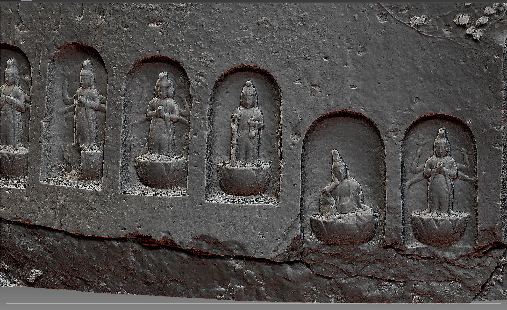 Photogrammetry from 672 photos taken with D750 and HERO5 Session in May 2019 Address is Yabuki , Fukushima ,Japan(福島県西白河郡矢吹町滝八幡112) GoogleMap: https://goo.gl/maps/sZvMfaUNffiXoFFk6 <br> 掲載許可済 Source: Objaverse 1.0 / Sketchfab
Colourful Cliffs of Kynance Cove, Cornwall
If that's not too much of a tongue-twister, these are the real colours of these cliffs on the Lizard Peninsula, Cornwall. The bright reds and greens are a mineral called serpentine. Captured with @Scaniverse Source: Objaverse 1.0 / Sketchfab
ScienceDex guides
Understand access before you commit
These curated guides explain access requirements, typical timelines, costs, and reuse considerations for widely used research datasets.
Allen Brain Atlas
Allen Brain Atlas is an Allen Institute collection of brain map atlases, datasets, APIs, and analysis tools covering mouse, human, and non-human primate brain resources.
Annotated Behaviour and Observability Dataset (ABODe)
ABODe is a University of Edinburgh DataShare dataset for behavior classification in group-housed mice using home-cage video, identities, bounding boxes, ground-plate positions, and annotator labels.
DANDI Archive for NWB datasets
DANDI is a BRAIN Initiative archive for publishing and sharing neurophysiology data, including electrophysiology, optophysiology, and behavioral data packaged as NWB and related standards.
International Brain Laboratory public data
The International Brain Laboratory public data releases expose standardized mouse decision-making experiments, including Neuropixels recordings, widefield calcium imaging, behavior, and session metadata accessed through the ONE API.
OpenNeuro
OpenNeuro is a free, open platform for sharing neuroimaging datasets, with public search, dataset pages, and download paths for web, S3, DataLad, and the OpenNeuro CLI.