
Find research datasets worth reusing
Search datasets from major research repositories and use ShareScore to quickly assess how well each record supports discovery, access, and reuse.
1,989
datasets available to search
ShareScore release 0.9.0
Dataset results
1,989 results for “Fires”
Royal Arsenal Fire Bucket
Metal fire bucket found (by Peter Barry) in Tump 39, Thamesmead - formerly part of the Royal Arsenal site, the Tump housed Naval heavy munitions. Tump built 1897, this area of the Arsenal ceased operations in the 1960's. Pete Barry's scan of the same bucket can be seen here: https://skfb.ly/osPKy 546 photos taken in February 2022 with a Sony a7R III and processed in Reality Capture. Source: Objaverse 1.0 / Sketchfab
Fire Basket
This is a low poly fire basket that has been used in several of my games Source: Objaverse 1.0 / Sketchfab
Water tank for fire prevention
March 10, 1945, at the end of the Asia Pacific War, there was an indiscriminate bombing raid called Great Tokyo Air Raid,by the U.S. military. It lasted for over two hours and destroyed an area of downtown Tokyo, killing about 100,000 people. On the other hand, Japan also bombed China and other countries after the Manchurian Incident. Many people were burned, damaged, and lost their lives in air raids. Most of them were civilians, including women, children and the elderly. Even today, Air Raids are still being carried out around the world. 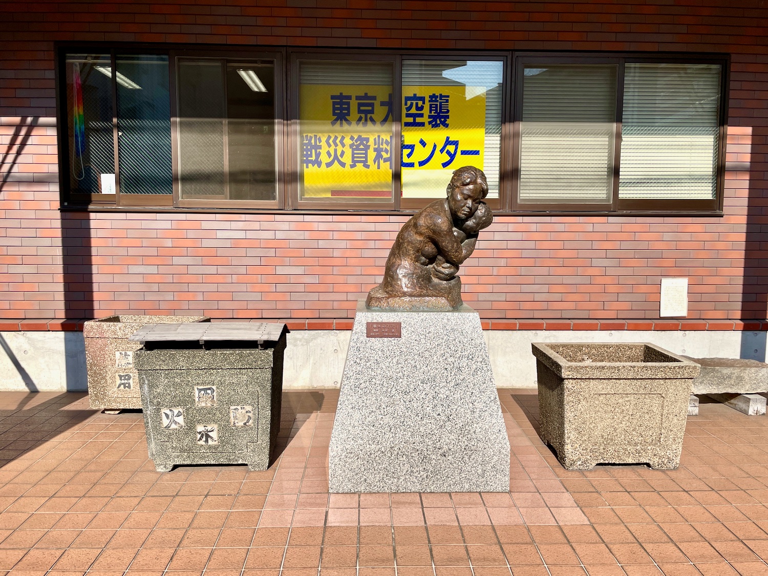 Source: Objaverse 1.0 / Sketchfab
Philadelphia Fire Insurance Mark
I used image to lithophane (http://3dp.rocks/lithophane/) and an image of the Philadelphia Fire Mark "Clasped Hands" to create this file. I was facinated by the marks while visiting Philadelphia and was hoping to find one that could be printed. I have not been able to so I made this one. The explanation of the marks can be found in this link: http://www.phillymag.com/property/2013/05/03/the-storied-fire-marks-of-philadelphia/ Source: Objaverse 1.0 / Sketchfab
Dan Yakuba People Poro Society Fire Runner Mask
Carved wood with dark brown patina of face in oval form with minimal features, round eyes overlaid with white metal and red fabric covering entire eye area, flat nose, large lips with small opening, indigenous blue & white fabric with 3 rows of cowrie shells adorns crown, indigenous fabric with handmade bells, cowrie shells and herbal medicine packets affixed to chin, holes around outer rim for attachment. Source: Objaverse 1.0 / Sketchfab
WW1 firing position, Ruukinranta, Espoo, Finland
First World War type D firing position for three riflemen in base XXXVI:1 in [Krepost Sveaborg](https://en.wikipedia.org/wiki/Krepost_Sveaborg) land front defense line in Ruukinranta, Espoo, Finland. The base was built in 1915 - 1918. This the only intact type D firing position in the whole land front. More info: * [Location in Google Maps](https://goo.gl/maps/CgBAJGqCSb6ZAh5T9) * [Wikipedia: Krepost Sveaborg](https://en.wikipedia.org/wiki/Krepost_Sveaborg) * [John Lagerstedt , Markku Saari: Krepost Sveaborg](http://www.novision.fi/viapori/eavaus.htm) * [Finnish Heritage Agency site info](https://www.kyppi.fi/to.aspx?id=112.1000008112) (only in finnish) Source: Objaverse 1.0 / Sketchfab
Fired Clay with Finger and Thumb Impressions
This pre-Columbian artifact is a lump of fired clay that someone squeezed in their right hand, leaving behind deep finger and thumb impressions. It was recovered from Tick Island in Volusia County Florida and contains abundant freshwater sponge spicules, linking it to potter made in the region bewteen around 3,500 and 500 years ago. The artifact is housed at the Rollins College Archaeology Lab. Model by Ellie Minette. Source: Objaverse 1.0 / Sketchfab
Supporting Information for 'in situ fire emission factors for Malaysian tropical peatlands with the first investigation of the influence of physicochemical controls on peat fire emission factor variability'
<p>Two files containing:</p> <p>1. Raw mole fraction retrievals from our OP-FTIR spectra (as described in the paper)</p> <p>2. Calculated emission ratios used for the calculation of emission factors (as published in the paper)</p>
Variability of Global Fire Emissions - Data and Model Code
<p>Netcdf files including all relevant data for the manuscript entitled "Trends and variability of global fire emissions due to historical anthropogenic activities", submitted to Global Biogeochemical Cycles in 2017. </p> <p>FINALv2_presentday_2002-2009.nc: Monthly fire area burned and carbon emissions data from FINAL.2 for the years 2002 through 2009</p> <p>FINALv2C_*_1700-2009.ts.nc: Historical time series of monthly area burned and carbon emissions for natural, secondary, crop and pasture land cover for years 1700 to 2009</p> <p>vegn_fire.F90: The main module of FINAL.2 in the GFDL LM3</p>
Damage cadasters for wildland-urban interface fires in Chile, 2019-2022
<p><span>Wildland-urban interface (WUI) regions are particularly vulnerable to wildfires due to their proximity to both nature and urban developments, posing significant risks to lives and property. To enhance our understanding of the risk profiles in WUI areas, we analysed seven fire case studies in central Chile. </span></p> <p><span>In the paper <em>"</em><span><em>Modelling the vulnerability of urban settings to WUI fires in Chile",</em> </span>We developed a mixed-methods approach for conducting local-scale analyses which involved field surveys, remote-sensing through satellite and drone imagery, and GIS-based analysis of the collected data. The methodology led to the generation of a georeferenced dataset of damaged and undamaged dwellings, including 16 variables representing their physical characteristics, spatial arrangement, and the availability of fire suppression resources. A binary classification model was then used to assess the relative importance of these attributes as indicators of vulnerability. The analysis revealed that spatial arrangement factors have a greater impact on damage prediction than the structural conditions and fire preparedness of individual units. Specifically, factors such as dwelling proximity to neighbours, distance to vegetation, proximity to the border of dwelling groups, and distance from the origin of the fire substantially contribute to the prediction of fire damage. Other structural attributes associated with less affluent homes may also increase the likelihood of damage, although further data is required for confirmation. This study provides insights for the design, planning, and governance of WUI areas in Chile, aiding the development of risk mitigation strategies for both built structures and the broader territorial area.</span></p>
Woody plant diversity before and after the Horseshoe Two Fire in the Chiricahua Mountains, Arizona, USA
<p>Aim: Drastic changes in fire regimes are altering plant communities, inspiring ecologists to better understand the relationship between fire and plant species diversity. We examined the impact of a 90,000-ha wildfire on woody plant species diversity in an arid mountain range in southern Arizona, USA. We tested recent fire-diversity hypotheses by addressing the impacts of fire severity, fire variability, historical fire regimes, and topography on diversity.</p> <p>Location: Chiricahua National Monument, Chiricahua Mountains, Arizona. USA., part of the Sky Islands of the US-Mexico borderlands.</p> <p>Taxon: Woody plant species.</p> <p>Methods: We sampled woody plant diversity in 138 plots before (2002-2003) and after (2017-2018) the 2011 Horseshoe Two Fire in three vegetation types and across fire severity and topographic gradients. We calculated gamma, alpha, and beta diversity and examined changes over time in burned vs. unburned plots and the shapes of the relationships of diversity with fire severity and topography.</p> <p>Results: Alpha species richness declined and beta and gamma diversity increased in burned but not unburned plots. Fire-induced enhancement of gamma diversity was confined to low fire severity plots. Alpha diversity did not exhibit a clear continuous relationship with fire severity. Beta diversity was enhanced by fire severity variation among plots and increased with fire severity up to very high severity, where it declined slightly.</p> <p>Main Conclusions: The results reject the intermediate disturbance hypothesis for alpha diversity but weakly support it for gamma diversity. Spatial variation in fire severity promoted variation among plant assemblages, supporting the pyrodiversity hypothesis. Long-term drought probably amplified fire-driven diversity changes. Despite the apparent benign impact of the fire on diversity, the replacement of two large conifer species with a suite of drought-tolerant shrubs signals the potential loss of functional diversity, a pattern that may warrant restoration efforts to retain these important compositional elements.</p>
Data from: fire in the rainforest: a 3,200-year history of fire in a West Kalimantan, Indonesia tropical rainforest
<p>Despite its perceived historical rarity, fire is an important disturbance in tropical rainforests. Very large rainforest fires have been observed multiple times in recent decades, often during years of strong El Niño-Southern Oscillation droughts. Fire in rainforest has major short-term consequences for humans and wildlife by converting forest to fire-prone fern, shrub, and grass, but the long-term effects remain to be seen. Borneo's indigenous groups have been using fire to clear land for centuries, yet the prevalence and spatial patterns of pre-modern fire across forest types in Borneo is not well understood. This research set out to reconstruct fire in a 1500-ha primary rainforest spanning 800 m of elevation in Indonesian Borneo with the goal of elucidating the role humans have played in rainforest fire. We found that humans played an important role in the occurrence of fire in recent centuries. Evidence of fire—charcoal >2 mm—is more abundant in forest types where humans would be more likely to live and/or practice swidden agriculture. However, pyrogenic material is ubiquitous across the study area, showing that all forest types have experienced fire. A set of 50 radiocarbon dates showed that in lowland areas—where human-caused fire is most likely—fire occurred throughout the last 3,200 years, peaking 1300-1600 CE. The upland areas lacked evidence of fire before 1250 CE but otherwise had a similar pattern to the lowlands. The period of high fire coincides with regional demographic changes as well as regional droughts documented elsewhere in Southeast Asia. In upland areas, fires likely burned only under regional drought when fires could more easily spread upslope. Although forest plot studies at this site show little structural evidence of past fires, tree diversity is lower than expected in the most burned areas (alluvial benches). Thus, our results suggest that land clearance was a major source of fire, but the current intact state of these rainforests indicates that they were largely resilient to fires and land use hundreds of years ago. Recent fires mirror patterns of fire spread that occurred hundreds of years ago, though their severity and extent is likely much greater.</p>
Global responses of plant abundance, diversity, and fitness to increased fire severity or frequency
<p>Database of responses of plant abundance, diversity, and fitness to increased fire frequency or severity, collected from published scientific articles or reports. The database includes 394 studies published worldwide between 1962 and 2023. Information on the following variables are also provided: fire regime component (fire frequency or severity), time since the last fire, fire type (wildfire or prescribed fire), historical fire regime type (surface or crown fire), plant life form (woody plant, herb, or bryophyte), habitat type, and climate. The database underpins the meta-analysis 'Global plant responses to intensified fire regimes', published in Global Ecology and Biogeography.</p>
Fire, elephants, and climate legacies enhance savanna resistance while impeding resilience
<p>Data accompanying the paper:</p> <p>L.M. Vermeulen, B. Verbist, K. Van Meerbeek, J. Slingsby, P.N. Bernardino, B. Somers. 2024. Fire, elephants, and climate legacies enhance savanna resistance while impeding resilience.</p>
Data from: Tamm Review: a meta-analysis of thinning, prescribed fire, and wildfire effects on subsequent wildfire severity in conifer dominated forests of the Western US
<p>Increased understanding of how active forest management (i.e., mechanical thinning, prescribed burning, and managed wildfire) affects subsequent wildfire severity is urgently needed as people and forests face a growing wildfire crisis. In response, we reviewed scientific literature for the US West and completed a meta-analysis that answered three questions: (1) How much do treatments reduce wildfire severity within treated areas? (2) How do the effects vary with treatment type, treatment age, and forest type? (3) How does fire weather moderate the effects of treatments? We found overwhelming evidence that mechanical thinning with prescribed burning, mechanical thinning with pile burning, and prescribed burning only are effective at reducing subsequent wildfire severity, resulting in reductions in severity from 62% to 72% relative to untreated areas. In comparison, thinning only was less effective – underscoring the importance of treating surface fuels when mitigating wildfire severity is the management goal. The efficacy of these treatments did not vary among forest types assessed in this study and was high across a range of fire weather conditions. Prior wildfire had more complex impacts on subsequent wildfire severity, which varied with forest type and initial wildfire severity. Across treatment types, we found that effectiveness of treatments declined over time, with the mean reduction in wildfire severity decreasing nearly threefold when wildfire occurred greater than 10 years after initial treatment. Our meta-analysis provides up-to-date information on the extent to which active forest management reduces wildfire severity and facilitates better outcomes for people and forests during future wildfire events. </p>
Ecosystem-wide responses to fire and large mammal herbivores in an African savanna
<p>Fire and large mammal herbivores (LMH) are the principal top-down forces maintaining savanna structure. Nonetheless, experiments designed to investigate interactions between fire and LMH are rare in savannas, and relationships between environmental variation and biodiversity in the context of fire and LMH are poorly understood. This study addresses these gaps by manipulating the presence of LMH and early and late dry season fires in a tropical African savanna. In addition, this work simultaneously explores environmental variables including soil and foliar quality, vegetation cover, and nearby water sources to more holistically describe factors affecting savanna functioning and biodiversity. </p> <p>After one year of experimental treatments, changes in vegetation were already apparent. Shrub abundance and richness and grass richness were higher in the absence of LMH, while grass biomass increased three-fold in burned plots as compared to unburned plots. Foliar nutrients tended to increase in open plots, while phenolics decreased. Amphibian abundance decreased with early burns and was higher with LMH. In contrast, small mammal abundance and richness increased without LMH and with time since fire. Richness and foraging of LMH were highest after late burns.</p> <p>These results demonstrate ecosystem-wide effects of LMH, illustrating the importance of considering multiple taxa when designing fire management programs. For example, burning negatively affected amphibians and small mammals and changed vegetation at the same time it increased LMH foraging. In the long-term, this experiment will shed light on interacting effects of fire and LMH on savanna biodiversity and function. </p>
Wildland fire PM2.5 modeled estimates for the US from 2008-2018
<p>This dataset includes daily modeled wildland fire PM<sub>2.5 </sub>concentrations for 2008-2018 for the state of California at a 12-km grid spatial resolution, estimated using the U.S. EPA's Community Multiscale Air Quality (CMAQ) (v. 5.0.1- 5.3) modeling system. These wildland fire emissions estimates (which include wildfires and prescribed burns [but exclude agricultural burns]) incorporate multiple sources of fire activity. SMARTFIRE2 was used to reconcile the sources of fire activity data. Fuel consumption was calculated using the U.S. Forest Service's CONSUME ver. 3.0 fuel consumption model and the Fuel Characteristic Classification System (FCCS) fuel-loading database in the BlueSky Framework. Emission factors were taken from the Fire Emission Production Simulator (FEPS) model. Non-fire emissions sources are from the National Emissions Inventory (NEI). The model was run with all emissions (fire and non-fire sources) and again without fires. The calculated difference between these simulations ('all sources PM<sub>2.5</sub>'<sub> </sub>and 'non-fire PM<sub>2.5</sub>') isolates the fire contribution, or 'fire-only PM<sub>2.5</sub>', which is the dataset provided here. </p>
Effects of fire and invasive plants on tropical dry forest restorartion
<p>The data collected is part of monitoring the ecological restoration process in a tropical dry forest. In this process, my research team conducted an experimental exercise, aiming to assess the natural regeneration around planted seedlings in burned sites compared to unburned sites. Additionally, we aimed to examine the effects of invasive species recruits and ruderal vegetation removal on seedlings and natural regeneration in both burned and unburned sites. For this research, we measured the planted seedlings and recorded the following data: height, weight, crown diameter, amount of radiation, and distance from the remaining forest edge. Furthermore, we counted the number of recruits, identified and searched for invasive potential in another database such as CABI.</p> <p>The planted seedlings were measured at two times; the first measurement was taken four months after planting, immediately after removing the ruderal vegetation around them. Forty-five days later, another round of ruderal vegetation removal in the plots was conducted, and after an additional 75 days, a final characterization of regeneration was performed</p>
Dataset related to the manuscript Wagner and Schepanski (submitted to JAMES, 2024): "Quantifying fire-driven dust emissions using a global aerosol model"
<p>This dataset belongs to the manuscript of Wagner and Schepanski (2024) entitled "Quantifying fire-driven dust emissions using a global aerosol model" submitted to the "Journal of Advances in Modeling Earth Systems (JAMES)".</p> <p>It contains the for the 10 year simulation period 2004-2013 the monthly, seasonal, or yearly averaged fields of the variables (variable name in brackets) that were used to prepare the plots and statements made in the manuscript. These are in detail:</p> <ol> <li>GFAS input data of FRP (frp)</li> <li>simulated AOD (tau_2d_550nm) and dust AOD (tau_comp_du_550nm)</li> <li>simulated wind-driven (emi_du_dust) and fire-driven (emi_du_fdust) dust emission fluxes</li> <li>simulated atmospheric dust concentration (du_all) including the soluble/insoluble coarse (du_ci, du_cs) and accumulation (du_ai, du_as) mode together with vertical atmospheric pressure levels (pfull)</li> </ol> <p>The simulated results are provided for both simulations, the <strong>control run</strong> without the additional fire-dust emissions and the actual <strong>firedust simulation</strong> with the new fire-dust emission parameterization.</p>
Spatiotemporal evolution of a controlled forest fire near Torre do Pinhão (Portugal)
<p>This dataset represents part of the propagation of a controlled forest fire on March 1, 2019, near Torre do Pinhão, Portugal. The data was generated from a 15-minute video captured using a UAV. The video's description, frame selection and segmentation process are available at https://doi.org/10.5281/zenodo.7944963.<br>The data represents the evolution of the burned region divided into 170 slices. Each slice is represented by a source polygon (S), a target polygon (T) and a one-to-one mapping of the vertices of S in T. Each polygon represents the burned region at a given time instant and each slice represents the evolution of the burned region during a time interval. These data are the inputs of interpolation methods to create a continuous representation of the fire spread, even when the original video frames are not good, for instance, due to occlusion of the area of interest by smoke. Figure <em>goodCorrespondences.png</em> shows an example of the correspondences between two polygons and the <a title="Interpolation" href="https://tinyurl.com/y4xwvwsb" target="_blank" rel="noopener">video</a> presents the evolution of the burned region obtained using a simple linear interpolation method. The dataset was created using a supervised method. The source code and method description are available on <a href="https://github.com/josemoreiraUA/EES_dataLab" target="_blank" rel="noopener">gitHub</a>.</p> <ul> <li><em>source</em>: the url of the original video (raw data) in zenodo.</li> <li><em>eventData</em>: the date and time of the prescribed forest fire.</li> <li><em>location</em>: the name of the place of the prescribed fire.</li> <li><em>coordinates </em>and <em>coordinatesDMS</em>: the coordinates of the prescribed fire in WSG84. The later represents the coordinates in degrees, minutes and seconds.</li> <li>numberOfFrames: the number of frames extracted from the video.</li> <li><em>correspondences</em>: this is a data structure to represent the correspondences between the polygons delimiting the extent of the burned area in frames (1, 2), (2, 3), … , (169, 170). The key is the number of the slice in [1, 170] and the value is a dictionary with the following keys: <ul> <li><em>frameNbInVideo_source</em>: the number of the frame corresponding to the source polygon for the slice.</li> <li><em>elapsedTimeInVideo_source</em>: the elapsed time in milliseconds since the beginning of the video.</li> <li><em>frameNbInVideo_target</em>: the number of the frame corresponding to the source polygon for the slice.</li> <li><em>numberOfVertices</em>: the number of vertices of the source and target polygons.</li> <li><em>vertexMappings</em> versus <em>sourceCoords </em>and <em>targetCoords</em>: The correspondences between the source and target vertices in each slice are represented in two distinct but equivalent formats. In <strong><em>data_fmtA</em></strong>, the list <em>sourceCoords </em>holds the coordinates (x,y) of the source vertices and the list <em>targetCoords </em>holds the coordinates of the target vertices. The two lists have the same length and the correspondence is given by the position in the list. In <em><strong>data_fmtB</strong></em>, the correspondences are represented in the list <em>vertexMapings </em>where each entry holds the coordinates of the source and corresponding target vertices.</li> </ul> </li> </ul> <p>Note that the target polygon in slice <em>i</em> and the source polygon in slice <em>i+1</em> are geometrically identical but they are topologically distinct because the number of vertices differs. This is to ensure that there is a one-to-one correspondence between the vertices of the source and target polygons in each slice. It is up to the vertex correspondence algorithm to add vertices to the source and target polygons to obtain a one-to-one correspondence between those polygons, as described on github. Click here to display a figure with an example of correspondences between the vertices of a source and a target polygons representing the extent of the burned area at two times.</p>
ScienceDex guides
Understand access before you commit
These curated guides explain access requirements, typical timelines, costs, and reuse considerations for widely used research datasets.
Allen Brain Atlas
Allen Brain Atlas is an Allen Institute collection of brain map atlases, datasets, APIs, and analysis tools covering mouse, human, and non-human primate brain resources.
Annotated Behaviour and Observability Dataset (ABODe)
ABODe is a University of Edinburgh DataShare dataset for behavior classification in group-housed mice using home-cage video, identities, bounding boxes, ground-plate positions, and annotator labels.
DANDI Archive for NWB datasets
DANDI is a BRAIN Initiative archive for publishing and sharing neurophysiology data, including electrophysiology, optophysiology, and behavioral data packaged as NWB and related standards.
International Brain Laboratory public data
The International Brain Laboratory public data releases expose standardized mouse decision-making experiments, including Neuropixels recordings, widefield calcium imaging, behavior, and session metadata accessed through the ONE API.
OpenNeuro
OpenNeuro is a free, open platform for sharing neuroimaging datasets, with public search, dataset pages, and download paths for web, S3, DataLad, and the OpenNeuro CLI.