
Find research datasets worth reusing
Search datasets from major research repositories and use ShareScore to quickly assess how well each record supports discovery, access, and reuse.
712
datasets available to search
ShareScore release 0.9.0
Dataset results
712 results for “towns”
Repository for data used in STOTEN article "Impacts of town characteristics on the changing urban climate in Vantaa"
<p>This dataset contains data used in the Science of The Total Environment journal article "Impacts of town characteristics on the changing urban climate in Vantaa" (https://doi.org/10.1016/j.scitotenv.2020.138471). The dataset includes:</p> <ul> <li>SURFEX air-surface interaction model results</li> <li>Observations from Helsinki-Vantaa airport</li> </ul> <p>SURFEX.zip contains SURFEX outputs used in the results section of the article.</p> <p>Verification_data.zip contains SURFEX outputs and meteorological observations used in the verification section of the article.</p> <p>E104.zip, E106.zip, E204.zip and E206.zip contain full SURFEX outputs for the four experiments conducted: A synthetic reference year representing the climate of the period 1980-2009 with no intervention (E104) and with green intervention (E106) and similarly for 2050s climate (E204 and E206).</p> <p>The STOTEN article "Impacts of town characteristics the changing urban climate in Vantaa" by Olli Saranko, Carl Fortelius, Kirsti Jylhä, Kimmo Ruosteenoja, Erika Brattich, Silvana Di Sabatino and Väinö Nurmi is provided in pdf-file 1-s2.0-S0048969720319847-main.pdf. The article is published in Science of The Total Environment journal, and is under a Creative Commons license (https://creativecommons.org/licenses/by-nc-nd/4.0/). This version is the pre-proof version.</p>
Figure 1 in Review of Loxopus Townes (Hymenoptera, Ichneumonidae, Cryptinae), with descriptions of six new species
Figure 1. Loxopus australis, habitus.
Figure 6 in Review of Loxopus Townes (Hymenoptera, Ichneumonidae, Cryptinae), with descriptions of six new species
Figure 6. Ovipositor apex. (A) L. ichilus. (B) L. multicolor; (C) L. tenuis; (D) L. venezuelanus.
Figure 5 in Review of Loxopus Townes (Hymenoptera, Ichneumonidae, Cryptinae), with descriptions of six new species
Figure 5. Ovipositor apex. (A) L. australis; (B) L. dodecius; (C) L. duckei; (D) L. exius.
Town of Ennis traffic calming project August - October 2020
<p>The Western Transporation Institute in partnership with the Town of Ennis and the Montana Department of Transportation conducted a temporary traffic calming project on Main Street in Ennis, MT. The project was installed on August 3rd and was removed on October 19th. The traffic calming included the use of curb extensions, road diets, crosswalks, and restriping to simulate a reconstruction project. The goal of the project was to improve safety for pedestrians along and crossing Main St. Pre-installation data collection was conducted between July 24th and July 30th and post-installation data collection was conducted between September 3rd and September 8th. Speed & volume data, pedestrian counts, and driver yielding rates data were all collected before and after the installation of the traffic calming to determine any impact on these indicators. In addition, a community survey was created in partnership with the Town of Ennis to get feedback from community members and visitors about the project, it's perception, and perceived impact. </p>
Spina (Comacchio - FE). Dataset of UAV orthophotos of the surroundings of the Etruscan town.
<p>This dataset contains a set of UAV orthophotos acquired from September 2020 to April 2023. For technical reasons the dataset was divided into 4 subsections, to be viewed together in GIS. The pictures were acquired to map soil marks. Every picture of the dataset cointains its metadata. The photos were acquired with a Mavic Air 2 and processed with the software Agisoft Metashape to generate the orthophotos. The georeferencing was made in ArcgisPro thanks to ground control points.</p>
Pasadena town hall staircase -- LiDAR iPad Pro
Captured three stories of the Pasadena Town Hall in one go with the new LiDAR iPad Pro. Texture came out pretty well considering I only gave it single go. Captured with the Polycam LiDAR scanning app: http://polycam.ai/ Source: Objaverse 1.0 / Sketchfab
Ghost Town Buildings
Two empty buildings, 4k textures. <br> Modeled after a few buildings from a western ghost town I found while browsing google images. Source: Objaverse 1.0 / Sketchfab
Uxbridge Town Pump
The plaque nearby reads: "Uxbridge was supplied with piped water until c.1800 when the Grand Junction Canal was built severing the old timber pipes. Wells then had to be dug in the Town Centre and this pump is the "last relic of the second stage of the attempts to supply the people of Uxbridge with water". The pump has been restored to its original location. It was unveiled by the Mayor, Councillor E. Hales, on the 15th of December 1988." It is located outside St Margaret's Church, Windsor Street, Uxbridge. Date: post 1800. Renovated and restored in 1988. Source: Objaverse 1.0 / Sketchfab
Priest-town ogham stone
A standing stone with a weathered ogham inscription located in a field in the townloand of Priest-town, Co. Tipperary, close to the border with Co. Waterford. 3d model created using photogrammetry (58 images in August 2016) and processed with Agisoft PhotoScan Source: Objaverse 1.0 / Sketchfab
Cave and Medieval town of Los Casares (Spain)
The Cave and Islamic town of Los Casares are located 3 kilometers north of the small town of Riba de Saelices (Guadalajara, Castilla-La Mancha). It is a zone of great natural beauty, crossed by the Linares river, and as a gateway to several valleys. The town sits on a hillside that is crowned at the top by a defensive tower built by Muslims around the 10th century AD. This tower allowed the control of the territory, especially the entrance and exit to the valleys located further north. The tower rises above the entrance to a cave that preserves an important set of Paleolithic paintings and engravings. Inside the cave it has been possible to find archaeological remains from different periods. The oldest belong to Neanderthals. 3D models made using FARO Focus 3D scan data and drone-based photogrammetry in Reality Capture software. Additional processing was completed in Geomagic Wrap, InstantMeshes, Meshlab, and Blender. Source: Objaverse 1.0 / Sketchfab
Coat of arms in old town of Cáceres (Spain)
ENGLISH: Coat of arms in old town of Cáceres (Spain) 3D model created using ContextCapture Master and Autodesk ReMake. ------------------------------------------------------------------------------------------------------------ ESPAÑOL Escudo de armas en el casco antiguo de Cáceres (España) Modelo 3D creado con ContextCapture Master y Autodesk ReMake. Source: Objaverse 1.0 / Sketchfab
Old Waverly Town Hall v2
An updated 3D scan of Old Waverly Town Hall restoration in Baltimore, MD. It was built in 1873 to serve as a public hall for the Waverly community. The city plans on restoring the building to its original 19th-century design. There has been a lot of progress since the last time I scanned it about three months ago. Some noticeable changes include the extension of the windows to their original length, restoration of the cornices, removal of fire escapes, repaired roof, and interior construction. Shot with a DJI Mavic Air 2, 750 photographs [Version 1](https://sketchfab.com/3d-models/old-waverly-town-hall-6376e15de51e4bbcbd1d3a754fa35231)  Before Construction 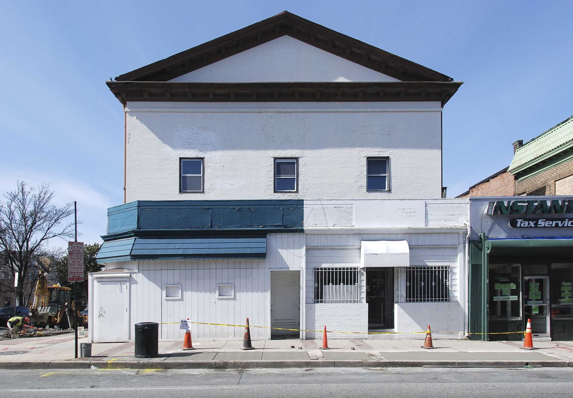 Rendering of renovations 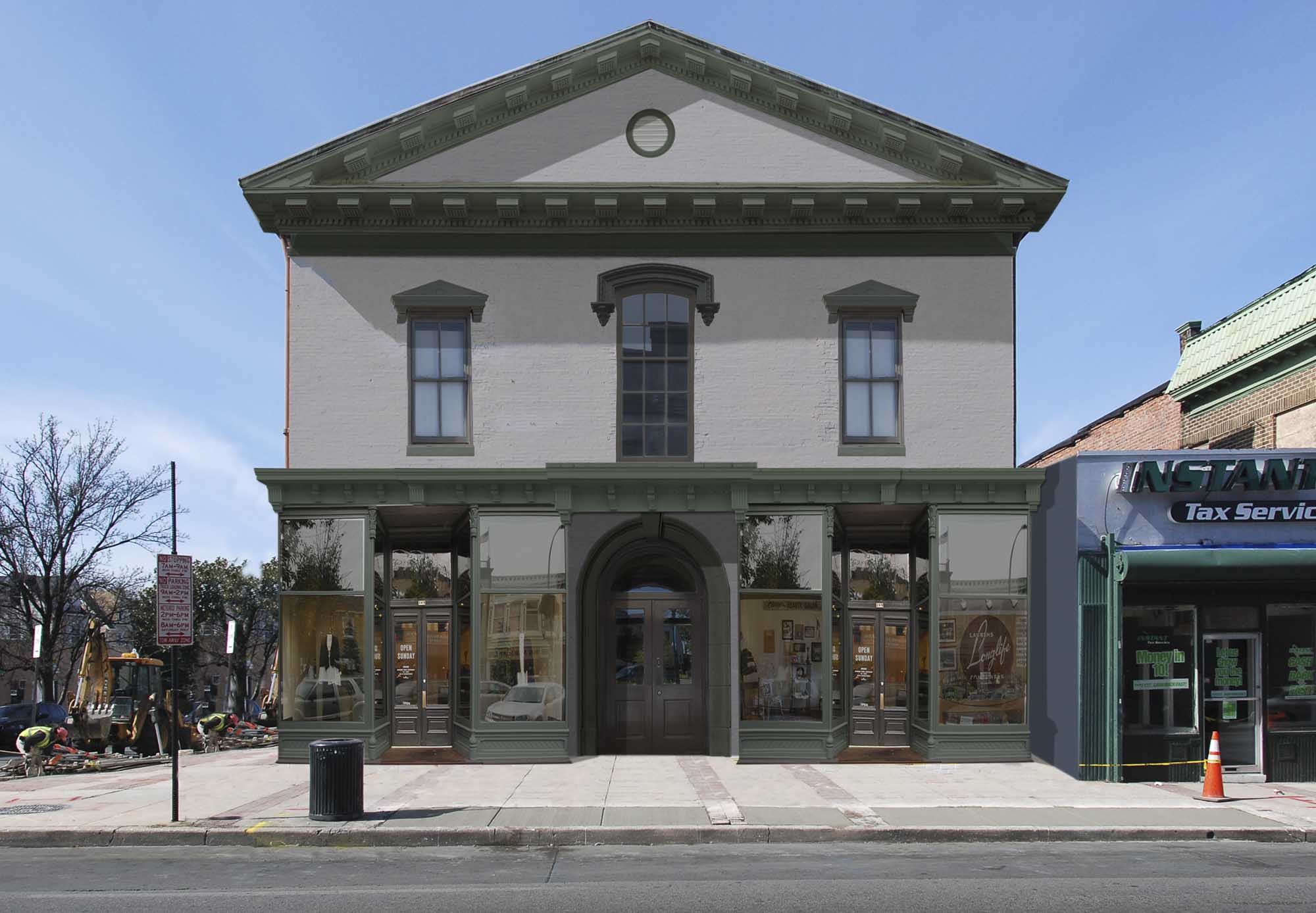 [Mahan Rykiel Associates Inc's ](https://www.mahanrykiel.com/portfolio/waverly-main-street-master-plan/) Source: Objaverse 1.0 / Sketchfab
Remains of the ancient town of Serdica
Located in Sofia, Bulgaria next to an ancient Roman temple and the Presidency. Source: Objaverse 1.0 / Sketchfab
Figure 32 from: Bordera S, González-Moreno A (2011) The species of the Neotropical genus Fractipons Townes, 1970 (Hymenoptera, Ichneumonidae, Cryptinae). ZooKeys 76: 55-72. https://doi.org/10.3897/zookeys.76.913
Figure 32 - Distribution of Fractipons species.
Figure 2 from: Nasu T, Kitagawa K, Karasawa S (2018) Species compositions of terrestrial isopods in public parks of a commuter town in Japan. In: Hornung E, Taiti S, Szlavecz K (Eds) Isopods in a Changing World. ZooKeys 801: 389-399. https://doi.org/10.3897/zookeys.801.21875
Figure 2 Frequencies of species richness of native, exotic, and total species in parks
Figure 5 in Creagrura Townes, 1971 and Ptilobaptus Townes, 1971 (Hymenoptera: Ichneumonidae) from Brazilian Amazon: new records and comments
Figure 5. Geographic distribution of Ptilobaptus cinctus Townes, 1971. Legend: Brazilian state records are highlighted in gray. The circles represent the specimens: red for new records and blue for previous records.
Descriptive Statistics and Town level Geospatial Distribution of Archaeological Settlements of Turkey in Iron Age (1200 –330 BCE)
<p><strong>Context</strong></p> <p>This dataset is a byproduct of my phd thesis. It combines the Archaeological Settlements of Turkey (TAY) Project data with geo spatial data obtained from openstreetmaps.</p> <p><strong>Content</strong></p> <p>For each archaeological settlement, the data contains:</p> <ul> <li>active dates:</li> <li>geo spatial data which points to the town containing the settlement.</li> <li>information with respect to site type and its research status/methodology.<br> These are all contained in the file <code>taydata.json</code>.</li> </ul> <p>The associated <a href="https://www.kaggle.com/dkaane/data-extraction-protocol-for-iaasot">notebook</a> to this dataset gives how each file is produced.</p> <p>We give several important statistics with respect to regions, and cities of Turkey for the Iron Age.</p> <p>If you want to visualize the data on a map. You can use the <code>1200___330_bce_sites_of_turkey.umap</code> file.<br> Just download the file and visualize it on <a href="https://umap.openstreetmap.fr/en/">umap</a> or on <a href="https://www.kaggle.com/dkaane/framacarte.org/">framacarte</a></p> <p><strong>Acknowledgements</strong></p> <p>Without the immense effort of TAY Project and its researchers, this dataset would not be possible.</p>
Figures 1-7 in Contributions to the taxonomy of the Brazilian Leurus Townes, 1946 (Hymenoptera: Ichneumonidae, Metopiinae)
Figures 1-7. Leurus angustignathus, Female. (1) Face in frontal view. (2, 3) Detail of the mandible, with the presence of the ventral lobe short, in frontal view. (4) Lateromedial longitudinal carina of propodeum in dorsal view. (5) Lateromedial longitudinal carina in the first metasomal tergite in dorsal view. (6) Habitus. (7) Metasoma in ventral view. Scale bars: 200 μm (1), 100 μm (2), 100 μm (3), 200 μm (4), 200 μm (5), 1.0 mm (6) and 500 μm (7).
Part of Uplistsikhe Cave Town (Raw)
A part of the Uplistsikhe Cave Town, shot in a hurry. I'd like to get back there with a LiDaR. Shot on Sony RX100mk6, processed in Agisoft Metashape > The model is used without following CC Attribution license by Strategy Aghmashenebeli-Giorgi Vashadze political party [in their advertisement](https://www.youtube.com/watch?v=0myNMN4mWJc) Source: Objaverse 1.0 / Sketchfab
ScienceDex guides
Understand access before you commit
These curated guides explain access requirements, typical timelines, costs, and reuse considerations for widely used research datasets.
Allen Brain Atlas
Allen Brain Atlas is an Allen Institute collection of brain map atlases, datasets, APIs, and analysis tools covering mouse, human, and non-human primate brain resources.
Annotated Behaviour and Observability Dataset (ABODe)
ABODe is a University of Edinburgh DataShare dataset for behavior classification in group-housed mice using home-cage video, identities, bounding boxes, ground-plate positions, and annotator labels.
DANDI Archive for NWB datasets
DANDI is a BRAIN Initiative archive for publishing and sharing neurophysiology data, including electrophysiology, optophysiology, and behavioral data packaged as NWB and related standards.
International Brain Laboratory public data
The International Brain Laboratory public data releases expose standardized mouse decision-making experiments, including Neuropixels recordings, widefield calcium imaging, behavior, and session metadata accessed through the ONE API.
OpenNeuro
OpenNeuro is a free, open platform for sharing neuroimaging datasets, with public search, dataset pages, and download paths for web, S3, DataLad, and the OpenNeuro CLI.