
Find research datasets worth reusing
Search datasets from major research repositories and use ShareScore to quickly assess how well each record supports discovery, access, and reuse.
139
datasets available to search
ShareScore release 0.7.1
Dataset results
139 results for “Ruins”
Old Mandu (बूढ़ी मांडू/बूढ़ी मांडव), Dhār district, Madhya Pradesh. Line of ruined fortifications.
<p>Old Mandu (बूढ़ी मांडू/बूढ़ी मांडव), Dhār district, Madhya Pradesh. Line of ruined fortifications. Photo: 2/2010.</p>
Old Mandu (बूढ़ी मांडू), Dhār district, Madhya Pradesh. View of the main tank and ghāṭ, with associated ruin.
<p>Old Mandu (बूढ़ी मांडू), Dhār district, Madhya Pradesh. View of the main tank and ghāṭ, with associated ruin opposite. Photo 2010.</p>
Bhagdei (जामगढ़-भगदेई, Raisen district), Madhya Pradesh. General view of ruined shrine.
<p>Bhagdei (भगदेई, Raisen district), Madhya Pradesh. General view of ruined shrine to the east of the village at the end of the dam. Dedicated to Hanumān with supplementary images of Durgā, circa 12th century. Temple ruin located at <a href="http://wikimapia.org/#lang=en&lat=23.108137&lon=78.255208&z=19&m=bs&show=/36622703/%E0%A4%AD%E0%A4%97%E0%A4%A6%E0%A5%87%E0%A4%88-Bhagdei-ruins-of-Hanum%C4%81n-temple&search=Bhagdei">23°6'28"N 78°15'22"E</a>. Photograph October, 2008.</p>
Deo Barunark (देवबरनार्क Bhojpur district, Bihar). Ruined temple, general view.
<p>Deo Barunark (देवबरनार्क Bhojpur district, Bihar). Ruined temple, general view. Photograph by Henry Baily Wade Garrick in 1881-82.</p>
Old Mandu (बूढ़ी मांडू), Dhār district, Madhya Pradesh. Ruined temple.
<p>Old Mandu (बूढ़ी मांडू), Dhār district, Madhya Pradesh. Ruined temple, possibly 12th century. Photo 2/2010.</p>
Old Mandu (बूढ़ी मांडू), Dhār district, Madhya Pradesh. Ruined temple.
<p>Old Mandu (बूढ़ी मांडू), Dhār district, Madhya Pradesh. Ruined temple, probably late 11th century. Photo 2/2010.</p>
Paphos, Cyprus. Ruin of Latin cathedral.
<p>Ruin generally described as the Latin Cathedral, as documented in 1974; located approximately at 34°45'34"N 32°24'42"E.</p>
РИС. 1. Раковины ювенильных крымских клауЗиллид (A–C). A. Mentissa gracilicosta, г. КоШка, СимеиЗ, coll. В. Н. Попов, det. С. В. Леонов. B. Mentissa canalifera, окрестности с. Краснолесье, 23.08.2002, сoll.&det. С. В. Леонов. C. Cochlodina laminata, Артек «Дубрава», 27.05.1999, coll.?, det. С.В. Леонов. Раковины половоЗрелых Balea perversa (D–G). D. Между Виклебю и Ресмо, остров Эланд, ШвециЯ, 07.1958 (фото F. Welter-Shultes). Е. Девичий Замок, Палава, ЮжнаЯ МоравиЯ, ЧехиЯ, 26.09.1998 (фото M. Horsák). F. РаЗвалины Замка РейнграфенШтайн блиЗ Бад-Мюнстер-ам-Штайн, Рейнланд-Пфальц, ГерманиЯ (фото А. В. Сысоев). G. Яйла Южной Демерджи, АлуШта, Республика Крым, РоссиЯ, 14.11.2002, сoll. Н. М. Ковблюк, det. С. В. Леонов. Все иЗображениЯ в одном масШтабе. FIG. 1. Shells of juvenile Crimean clausillids (A–C). A. Mentissa gracilicosta, Koshka mountain, Simeiz, coll. V. N. Popov, det. S. V. Leonov. B. Mentissa canalifera, near Krasnolesye village, 23.08.2002, coll.&det. S. V. Leonov. C. Cochlodina laminata, Artek "Dubrava", 27.05.1999, coll.?, det. S.V. Leonov. Adult Balea perversa shells (D–G). D. Sweden, Öland, between Vickleby and Resmo, 07.1958 (photo F. Welter-Shultes). E. Dívčí hrad, South Moravia, Czech Republic, 26.09.1998 (photo by M. Horsák). F. Ruins of the Rheingrafenstein Castle near Bad Munster am Stein, Rheineland-Pfalz, Germany (photo by A.V. Sysoev). G. Yayla Yuzhnaya Demerdzhi, Alushta, Republic of Crimea, Russia, 14.11.2002, coll. N. M. Kovblyuk, det. S. V. Leonov. All images are at the same scale. in О достоверности находок Balea perversa (Gastropoda: Pulmonata: Clausiliidae) в Крыму
РИС. 1. Раковины ювенильных крымских клауЗиллид (A–C). A. Mentissa gracilicosta, г. КоШка, СимеиЗ, coll. В. Н. Попов, det. С. В. Леонов. B. Mentissa canalifera, окрестности с. Краснолесье, 23.08.2002, сoll.&det. С. В. Леонов. C. Cochlodina laminata, Артек «Дубрава», 27.05.1999, coll.?, det. С.В. Леонов. Раковины половоЗрелых Balea perversa (D–G). D. Между Виклебю и Ресмо, остров Эланд, ШвециЯ, 07.1958 (фото F. Welter-Shultes). Е. Девичий Замок, Палава, ЮжнаЯ МоравиЯ, ЧехиЯ, 26.09.1998 (фото M. Horsák). F. РаЗвалины Замка РейнграфенШтайн блиЗ Бад-Мюнстер-ам-Штайн, Рейнланд-Пфальц, ГерманиЯ (фото А. В. Сысоев). G. Яйла Южной Демерджи, АлуШта, Республика Крым, РоссиЯ, 14.11.2002, сoll. Н. М. Ковблюк, det. С. В. Леонов. Все иЗображениЯ в одном масШтабе. FIG. 1. Shells of juvenile Crimean clausillids (A–C). A. Mentissa gracilicosta, Koshka mountain, Simeiz, coll. V. N. Popov, det. S. V. Leonov. B. Mentissa canalifera, near Krasnolesye village, 23.08.2002, coll.&det. S. V. Leonov. C. Cochlodina laminata, Artek "Dubrava", 27.05.1999, coll.?, det. S.V. Leonov. Adult Balea perversa shells (D–G). D. Sweden, Öland, between Vickleby and Resmo, 07.1958 (photo F. Welter-Shultes). E. Dívčí hrad, South Moravia, Czech Republic, 26.09.1998 (photo by M. Horsák). F. Ruins of the Rheingrafenstein Castle near Bad Munster am Stein, Rheineland-Pfalz, Germany (photo by A.V. Sysoev). G. Yayla Yuzhnaya Demerdzhi, Alushta, Republic of Crimea, Russia, 14.11.2002, coll. N. M. Kovblyuk, det. S. V. Leonov. All images are at the same scale.
Bhadravati भद्रावती (Chandrapur District) Maharashtra. Ruined Temple in Dolara Talab.
<p>Bhadravati भद्रावती (Chandrapur District) Maharashtra. Ruined temple in Dolara Talab, with stone causeway, <em>circa</em> 11th century.</p>
Bhadner भाद्नेर (Raisen district, Madhya Pradesh). Ruined temple, ceiling detail
<p>Bhadner भाद्नेर (Raisen district, Madhya Pradesh). Ruined temple, ceiling detail</p>
Bhadner भाद्नेर (Raisen district, Madhya Pradesh). Ruined temple, maṇḍapa exterior.
<p>Bhadner भाद्नेर (Raisen district, Madhya Pradesh). Ruined temple, maṇḍapa exterior.</p>
Eran (ऐरण Madhya Pradesh, India). View of the Varāha image and ruins (c. 1892-94).
<p>Eran (ऐरण Madhya Pradesh, India). View of the Varāha image and ruins (c. 1892-94).</p>
Orthomosaics and digital elevation model of the 'Bear Trap' - a Norse ruin in Northwest Greenland
<p>This dataset consists of a digital elevation model (DEM) and an orthomosaic of the ‘Bear Trap’ (also called ‘Bjørnefælden’ in Danish, and ‘Putdlagssuaq’ or ‘The Great Trap’ Greenlandic Kalaallisut), a Norse ruin at the western end of the Nuussuaq Peninsula in NW Greenland. Images comprise 1032 low-altitude aerial images acquired from an unoccupied aerial vehicle (DJI Phantom 3 Standard). These images were processed using Agisoft Metashape Pro (v1.7; Linux Ubuntu) following the USGS protocols for processing imagery in coastal areas. The locations of 8 ground control points (GCPs) were surveyed with a high accuracy global navigation satellite system (GNSS) receiver (Emlid Reach). The base station and rover data were processed using the Emlid distribution of the free RTKLib software (<a href="https://docs.emlid.com/reach/common/tutorials/gps-post-processing/">https://docs.emlid.com/reach/common/tutorials/gps-post-processing/</a>). Geoid height was computed using the online UNAVCO Geoid Height Calculator (<a href="https://www.unavco.org/software/geodetic-utilities/geoid-height-calculator/geoid-height-calculator.html">https://www.unavco.org/software/geodetic-utilities/geoid-height-calculator/geoid-height-calculator.html</a>). During the image alignment step in Metashape, the ‘High’ accuracy setting and key point and tie point limits of 60000 and 0 were used. Generic and reference preselection were not used. Gradual selection was used to remove tie points that exceeded thresholds for the projection accuracy, reconstruction uncertainty, and reprojection error and the intrinsic camera parameters were computed for each camera calibration group. GCPs were then imported and placed in each image. The dense point cloud was then computed using the ‘Ultra High’ quality setting, followed by the DEM and orthomosaic. The resolution of the orthomosaic is 1.83 cm/pixel. 5 cm resolution orthomosaic and DEM were also exported for use in QGIS. </p> <p> </p> <p>A complete file list is provided in the README file that accompanies this dataset.</p> <p> </p> <p>The image survey was conducted as part of the Vaigat Iceberg-Microbial Oil Degradation and Archaeological Heritage Investigation (VIMOA) project, which was funded by the Danish Centre for Marine Research and supported by the Arctic Research Centre at Aarhus University, in affiliation with the National Museum of Denmark, the Greenland Institute of Natural Resources, and The Greenland National Museum and Archives in Nuuk. Proper archaeological permits for the survey were obtained in advance from the Greenland National Museum and Archives in Nuuk. Walsh et al. (2020) provide an overview of the archaeological surveys conducted during the VIMOA project and Walsh et al. (in prep) provide further details specific to The Bear Trap and surrounding archaeological contexts observed during the 2019 survey.</p> <p>Walsh et al. (2020) The VIMOA project and archaeological heritage in the Nuussuaq Peninsula of north-west Greenland. <em>Antiquity</em> 94:e6 doi:10.15184/aqy.2019.230</p> <p>Walsh, Matthew J., Daniel F. Carlson, Pelle Tejsner, and Steffen Thomsen. The Bear Trap: Reinvestigating a unique stone structure on the northwest tip of the Nuussuaq Peninsula, Greenland. Submitted to <em>Arctic Anthropology</em>.</p>
Temple Of Augustus Ruins
Herod the Great's temple to Augustus near Pan's Cave in Banias, Israel. "When, later on, through Caesar's bounty he received additional territory, Herod there too dedicated to him a temple of white marble near the sources of the Jordan, at a place called Paneion. At this spot a mountain rears its summit to an immense height aloft; at the base of the cliff is an opening into an overgrown cavern; within this, plunging down to an immeasurable depth, is a yawning chasm, enclosing a volume of still water, the bottom of which no sounding-line has been found long enough to reach. Outside and from beneath the cavern well up the springs from which, as some think, the Jordan takes its rise; but we will tell the true story of this in the sequel" Source: Objaverse 1.0 / Sketchfab
Old house ruins, Espoo, Finland
Old house ruins in [Puustellinmäki](https://goo.gl/maps/KVUPjozmpDS6neBX8), Espoo, Finland. Source: Objaverse 1.0 / Sketchfab
Kolo - Castle Ruins - XIVc
Koło Castle - a Gothic castle, which according to Jan Długosz was raised by Casimir III the Great before the year of 1362 (when Koło received its town rights). The castle secured the route from Greater Poland to Łęczyca, in the lowlands of the River Warta. The castle is located on an artificial hill on a meander of the River Warta. During the raising of the castle, the river had a number of tributaries in the area, which were important for the castle's strategic location. Source: Objaverse 1.0 / Sketchfab
Lowerwell Ruined Building
A stone ruined building at Lowerwell (Well Farm), near Ugborough, Devon, England. OS Grid Ref: SX 68937 55714 722 photos taken in July 2020 with a Sony a6000 and processed in Agisoft Metashape. Building very overgrown with nettles so hard to photograph properly. Therefore some parts of model and texture are low quality. Source: Objaverse 1.0 / Sketchfab
574 Viking Ruins
Recreation of Greenlandic Viking ruins using both drone and camera photography. Near Sillisit, Greenland. Source: Objaverse 1.0 / Sketchfab
Southwark Cathedral Archaeological Ruins
Archaeology excavations in the Lancelot's Link on the north side of Southwark Cathedral, London. These remains we're revealed in 1999 and include a Roman road, part of the foundation of the Norman Priory, curve of a Norman apse and a medieval stone coffin. 298 photos taken in July 2021 with a Sony a6000 and processed in Reality Capture. Source: Objaverse 1.0 / Sketchfab
The Palenque ruins scans with iPhone12 Pro
The Palenque ruins scans with iPhone12 Pro In the inner sanctum of the Temple of the Cross at the Palenque ruins, one of the representative ruins of the Mayan civilization located in what is now the state of Chiapas in southern Mexico, there is a relief of a god smoking a cigar-shaped cigarette. This relief, which is currently the oldest document on tobacco, suggests that tobacco was once a sacred plant associated with the gods. [Tobacco & Salt Museum](https://www.tabashio.jp/en/) 1-16-3 Yokokawa, Sumida-ku, Tokyo 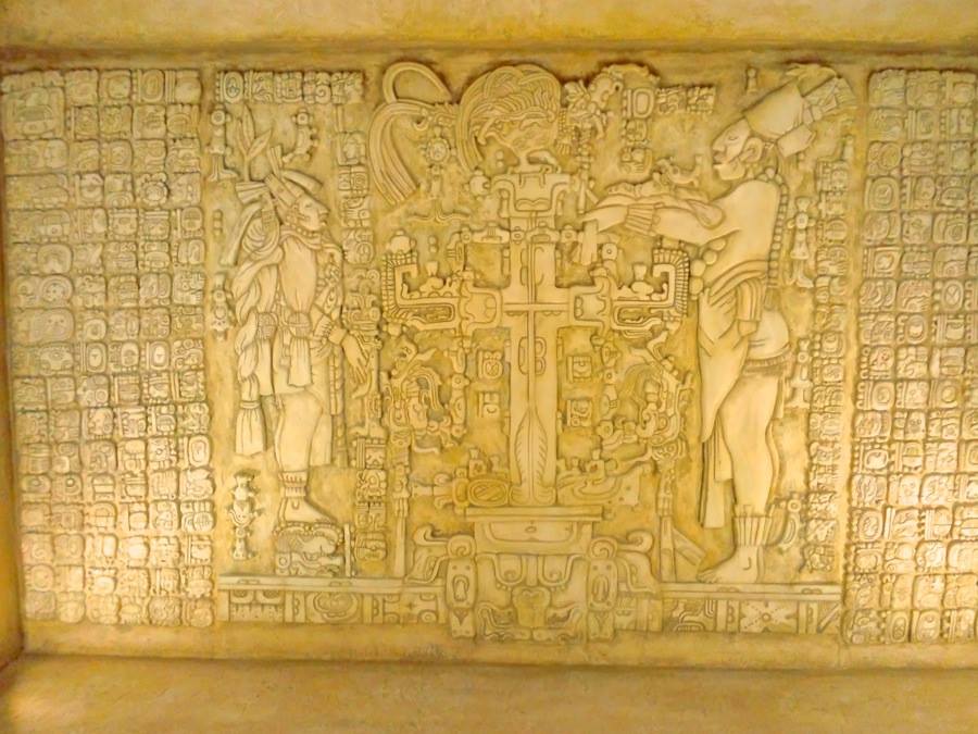 Source: Objaverse 1.0 / Sketchfab
ScienceDex guides
Understand access before you commit
These curated guides explain access requirements, typical timelines, costs, and reuse considerations for widely used research datasets.
Allen Brain Atlas
Allen Brain Atlas is an Allen Institute collection of brain map atlases, datasets, APIs, and analysis tools covering mouse, human, and non-human primate brain resources.
Annotated Behaviour and Observability Dataset (ABODe)
ABODe is a University of Edinburgh DataShare dataset for behavior classification in group-housed mice using home-cage video, identities, bounding boxes, ground-plate positions, and annotator labels.
DANDI Archive for NWB datasets
DANDI is a BRAIN Initiative archive for publishing and sharing neurophysiology data, including electrophysiology, optophysiology, and behavioral data packaged as NWB and related standards.
International Brain Laboratory public data
The International Brain Laboratory public data releases expose standardized mouse decision-making experiments, including Neuropixels recordings, widefield calcium imaging, behavior, and session metadata accessed through the ONE API.
OpenNeuro
OpenNeuro is a free, open platform for sharing neuroimaging datasets, with public search, dataset pages, and download paths for web, S3, DataLad, and the OpenNeuro CLI.